Advanced Land Observation Satellite
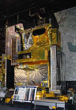
 ALOS model exposed at Tokyo Museum of Modern Art | |||
| Mission type | Earth observation | ||
|---|---|---|---|
| Operator | JAXA | ||
| COSPAR ID | 2006-002A | ||
| SATCAT № | 28931 | ||
| Website |
global | ||
| Mission duration | 5 years, 3 months, 18 days | ||
| Spacecraft properties | |||
| Manufacturer |
NEC Toshiba Mitsubishi Electric | ||
| Launch mass | 4,000 kg (8,800 lb)[1] | ||
| Dry mass | 3,810 kg (8,400 lb)[1] | ||
| Dimensions | 18.9 m × 27.4 m × 6.2 m (62 ft × 90 ft × 20 ft) | ||
| Power | 7000 watts | ||
| Start of mission | |||
| Launch date | 24 January 2006, 01:33 UTC[2] | ||
| Rocket | H-IIA rocket | ||
| Launch site | Tanegashima Space Center | ||
| End of mission | |||
| Disposal | decommissioned | ||
| Deactivated | 12 May 2011, 10:50 | ||
| Orbital parameters | |||
| Reference system | Geocentric | ||
| Regime | Sun-synchronous | ||
| Semi-major axis | 7,066 kilometres (4,391 mi)[3] | ||
| Perigee | 693.8 kilometres (431.1 mi)[3] | ||
| Apogee | 696.3 kilometres (432.7 mi)[3] | ||
| Inclination | 98.0 degrees[3] | ||
| Period | 98.5 minutes[3] | ||
| Epoch | 27 January 2015, 09:27:58 UTC[3] | ||
| Instruments | |||
|
PRISM: Panchromatic Remote-sensing Instruments for Stereo Mapping, to measure precise land elevation AVNIR-2: Advanced Visible and Near Infrared Radiometer type 2, which observes what covers land surfaces. 10-meter resolution at nadir PALSAR: Phased Array type L-band Synthetic Aperture Radar, which enables day-and-night and all-weather land observation | |||
| |||
Advanced Land Observing Satellite (ALOS), also called Daichi, is a 4-ton Japanese satellite launched in 2006. After five years of service, the satellite lost power and ceased communication with Earth, but remains in orbit.
Launch
ALOS was launched from Tanegashima, Japan, on 24 January 2006 by a H-IIA rocket. The launch had been delayed three times by weather and sensor problems.
Mission
The satellite contained three sensors that were used for cartography and disaster monitoring of Asia and the Pacific. JAXA initially hoped to be able to launch the successor to ALOS during 2011, but this plan did not materialize.
In 2008, it was announced that the images generated by ALOS were too blurry to be of any use for map making. Only 52 of 4,300 images of Japan could be updated based on data from ALOS.[4][5] Then, JAXA announced the problem was solved.[6]
ALOS was used to analyze several disaster sites.[7][8][9] Images of the devastated Japanese coast following the 2011 Tōhoku earthquake and tsunami were among the last major contributions from ALOS.[10][11]
Decommissioning

In April 2011, the satellite was found to have switched itself into power-saving mode due to deterioration of its solar arrays.[10] Technicians could no longer confirm that any power was being generated. It was suggested that meteoroids may have struck ALOS, creating the anomaly which eventually led to its shutdown.[12]
On 12 May 2011, JAXA sent a command to the satellite to power down its batteries and declared it dead in orbit.[10][13]
See also
- 2006 in spaceflight
- ADEOS II (predecessor spacecraft)
- ALOS-2 (successor spacecraft)
- Japan Coast Guard[11]
References
- 1 2 "ALOS (Advanced Land Observing Satellite) / Daichi". eoPortal.org. Retrieved 2 February 2015.
- ↑ "NASA - NSSDC - Spacecraft Details". NASA. Retrieved 2 February 2015.
- 1 2 3 4 5 6 "ALOS Satellite details 2006-002A NORAD 28931". N2YO. 2 February 2015. Retrieved 2 February 2015.
- ↑ "Japanese satellite flops at map-making: official". 8 January 2008.
- ↑ "Utilization of Data Acquired by "DAICHI"" (PDF). 16 January 2008.
- ↑ "陸域観測技術衛星「だいち」データの地図への利用に関する改善状況について". 9 April 2008.
- ↑ "ALOS (Daichi) observes Landslide in Leyte Island, Philippines". Japan Aerospace Exploration Agency. 2 March 2006.
- ↑ "Continuous monitoring of landslides area caused by Iwate-Miyagi Nairiku earthquake in 2008 using ALOS images" (PDF).
- ↑ "Latin America Volcano Monitoring With ALOS".
- 1 2 3 "Japanese Satellite Declared Dead in Orbit". Space.com. Retrieved 25 October 2013.
- 1 2 Last thank-you message to DAICHI from Japan Coast Guard - Advanced Land Observing Satellite "DAICHI" (ALOS) (JAXA webpage)
- ↑ Satellite Imaging Corporation, ALOS Satellite Sensor (2.5m) (Accessed 15 September 2015)
- ↑ "DAICHI (ALOS) Operation Completion". JAXA. 12 May 2011. Retrieved 25 October 2013.
External links
- Official website
- Paper on ALOS
- PALSAR sensor page
- JOY TO THE EARTH - "ALOS-Daichi" tells about life on our planet on YouTube