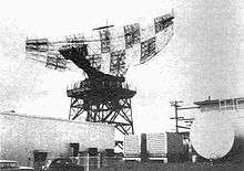
AN/FPS-24 Radar
 General Electric AN/FPS-24 Radar | |
| Country of origin | United States |
|---|---|
| Type | Long Range Search Radar |
The AN/FPS-24 Radar was a Long Range Search Radar used by the United States Air Force Air Defense Command.
General Electric was the prime contractor this frequency diverse (FD) long range search radar designed to operate in the Very High Frequency (VHF) at 214 to 236 MHz. There were problems with this radar at the test site at Eufaula AFS (Eufaula, Alabama) in 1960. These problems required many modifications. Acme Missiles & Construction Corp., Rockville Centre, N.Y. built the radar tower facilities at Missile Master, Pittsburgh Defense Area, Oakdale, Pa.[1]
Additional problems occurred when deployment was attempted in 1961 with the first production model at Point Arena Air Force Station in California. When the radar finally deployed, bearing problems often occurred due to the 85.5-ton antenna weight. Failures of the 9-foot hydrostatic bearing often caused the early closure of some sites due to catastrophic damage to the support tower, sail, and feed horn.
Twelve systems were built between 1958 and 1962. The prototype at Eufaula, Alabama, was perched atop a steel lattice structure tower of shorter (but unconfirmed) height. Depending on the location it was to be deployed in operational production, the radar antenna (sail) itself was perched atop one of two different towers: a cast-in-place concrete tower or a metal-sided steel-framed tower both with equal dimensions of 84'6" in height and side dimensions of 60'3" square (63'3" square when including the thickness of corner buttresses). This tower design was also used for the AN/FPS-35 frequency diverse SAGE search radar built by Sperry Corporation. The FPS-24 radar antenna sail rotated 5 revolutions per minute (a SAGE specification, but varied slightly depending on wind conditions) and was often the cause of microwave interference reported by nearby residents who could hear the radar signal in television and radio broadcasts. At some locations, the radar signal was "blanked" as it passed over television broadcast antenna sites such as Mt. Loma Prieta in the Santa Cruz Mountains, California. However, at DEFCON 3 or higher, the signal was ordered "unblanked" in all directions. The 7.5 Megawatt (maximum power) transmitter ran in normal operation at 5 Megawatt output pulse (nearly 20 microseconds in duration) and was conveyed from the transmitter to the antenna feed horn via a 9-inch diameter rigid coaxial connector. The feed horn consisted of a cross dipole antenna design for both A and B channels.
In operation
Two of the FPS-24 radar installations had the benefit of being covered by a fiberglass dome. One such installation was at Cottonwood Air Force Station, Idaho. The other was at Mt Hebo Air Force Station, Oregon.
Post-operation
Subsequent to USAF site closures, some FPS-24 radar units were upgraded to Air Route Surveillance Radar (ARSR) units for USAF-FAA joint surveillance duty.
Historical Designation
On May 10, 2016, the Santa Clara County Board of Supervisors voted unanimously to list the Almaden Air Force Station AN/FPS-24 concrete Radar Tower on the County Heritage Resource Inventory, thus giving it official historic status and demolition protection.[2]

The 85-foot concrete buildings that supported most of the FPS-24 antennas were prominent landmarks, and all remain standing.
- AL Eufaula 31°52′53″N 85°15′13″W / 31.8814°N 85.2536°W (prototype, steel lattice tower, demolished)
- CA Point Arena 38°53′19″N 123°32′59″W / 38.8886°N 123.5497°W (first production unit, concrete, present)
- CA Almaden 37°09′38″N 121°53′51″W / 37.1605°N 121.8976°W (second production unit, used for benchmarking all subsequent units, concrete tower, designated historic)
- ID Cottonwood 46°04′00″N 116°27′51″W / 46.0667°N 116.4643°W (steel tower, present)
- MI Port Austin 44°01′49″N 83°00′09″W / 44.0303°N 83.0025°W (concrete tower, present)
- MN Baudette 48°40′15″N 94°37′12″W / 48.6707°N 94.6201°W (concrete tower, present)
- MT Malmstrom 47°30′06″N 111°12′12″W / 47.5018°N 111.2034°W (steel tower, demolished)
- NC Winston-Salem 36°02′37″N 80°08′12″W / 36.0435°N 80.1366°W (concrete tower, present)
- PA Oakdale 40°23′57″N 80°09′24″W / 40.3991°N 80.1566°W (concrete tower, present)
- WA Blaine 48°54′43″N 122°44′05″W / 48.9119°N 122.7346°W (concrete tower, present)
- OR Mt. Hebo 45°12′57″N 123°45′28″W / 45.2158°N 123.7578°W (steel tower, demolished)
- ME Bucks Harbow 44°37′46″N 67°23′43″W / 44.6294°N 67.3953°W (steel tower, demolished)
References
![]() This article incorporates public domain material from the Air Force Historical Research Agency website http://www.afhra.af.mil/.
This article incorporates public domain material from the Air Force Historical Research Agency website http://www.afhra.af.mil/.
- ↑ Missiles and Rockets, April 17, 1961, p. 50.
- ↑ "Mount Umunhum cube to stay: Cold War relic gets historic designation". San Jose Mercury News. 10 May 2016. Retrieved 25 May 2016.
- AN/FPS-24 @ radomes.org
- AN/FPS-24 @ fas.org
- Winkler, David F. (1997), Searching the skies: the legacy of the United States Cold War defense radar program. Prepared for United States Air Force Headquarters Air Combat Command.
