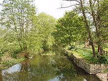
Abbey River
Chertsey Lock | ||||||||||||||||||||||||||||||||||||||||||||||||||||||||||||||||||||||||||||||||||||||||||||||||||||||||||||||||||||||||||||||||||||||||||||||||||||||||||||||||||||||||
|---|---|---|---|---|---|---|---|---|---|---|---|---|---|---|---|---|---|---|---|---|---|---|---|---|---|---|---|---|---|---|---|---|---|---|---|---|---|---|---|---|---|---|---|---|---|---|---|---|---|---|---|---|---|---|---|---|---|---|---|---|---|---|---|---|---|---|---|---|---|---|---|---|---|---|---|---|---|---|---|---|---|---|---|---|---|---|---|---|---|---|---|---|---|---|---|---|---|---|---|---|---|---|---|---|---|---|---|---|---|---|---|---|---|---|---|---|---|---|---|---|---|---|---|---|---|---|---|---|---|---|---|---|---|---|---|---|---|---|---|---|---|---|---|---|---|---|---|---|---|---|---|---|---|---|---|---|---|---|---|---|---|---|---|---|---|---|---|---|
Legend
| ||||||||||||||||||||||||||||||||||||||||||||||||||||||||||||||||||||||||||||||||||||||||||||||||||||||||||||||||||||||||||||||||||||||||||||||||||||||||||||||||||||||||
The Abbey River is a backwater of the River Thames in England, near Chertsey, Surrey in its northern green buffers adjoining mixed-use flood plain. It runs from the point opposite the midpoint of Penton Hook Island to below Chertsey Lock and forms half of the watercourse boundaries of Laleham Burway, a larger, artificial island which contains Laleham Golf Course and a fresh water waterworks.

History
The river, which was also known as Oxley, Oxlake or Oaklake Mill River was cut by the monks of Chertsey Abbey in the eleventh century to supply the mill closest to their monastery/abbey.
Abbey
This mill was one of several the institution owned in its vast Surrey estates — despite many sales of individual manors and small parcels of land to wealthy institutions, including Oxford and Cambridge Colleges (and Windsor Great Park at its greatest under Henry VIII, covering much of the land from Wokingham and Sandhurst, Berkshire to the River Wey). Underlining this immense wealth and the usefulness of an Abbey Mill for grain, the Valor Ecclesiasticus of 1535 gives the clear annual value (surplus) of the abbey as £659 15s. 8¾d.[1][2] In 1608 there were two watermills on the river recorded as the Oaklake Mylles.
Proposed as rival navigation
In 1809 the millers offered the stream as the Thames navigation channel in concert with City of London Corporation building a weir to protect Chertsey and Shepperton, and other areas downstream, from floods as well as keeping water levels sufficiently deep, but the latter decided to pursue its own shorter route plans, so built Chertsey Weir and Lock.[3] Much of the channel is lightly surrounded by trees and it is at most 980m from the River Thames.[4]
The site of the abbey was bought in 1861 by Mr Bartrop, the secretary to the Surrey Archaeological Society who have their museum at Guildford Museum. Among the appurtenances of the site of the abbey included in its title were the "watermills known as the Oxlake or Okelake mills" and "a small river or brook known as the Abbey River or the Bargewater".[5]
References
- ↑ H.E. Malden (editor) (1967). "House of Benedictine monks: Abbey of Chertsey". A History of the County of Surrey: Volume 2. Institute of Historical Research. Retrieved 21 October 2013.
- ↑ equivalent to £363,409 in 2015
- ↑ Fred. S. Thacker The Thames Highway: Volume II Locks and Weirs 1920 - republished 1968 David & Charles
- ↑ Grid Reference Finder distance tools
- ↑ H.E. Malden (editor) (1911). "Parishes: Chertsey". A History of the County of Surrey: Volume 3. Institute of Historical Research. Retrieved 21 October 2013.
| Next confluence upstream | River Thames | Next confluence downstream |
| River Colne (north) | Abbey River | River Bourne, Chertsey River Bourne, Addlestone (south) |
Coordinates: 51°23′34″N 0°29′20″W / 51.39278°N 0.48889°W