Acala Ch'ol

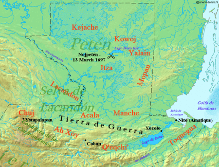
The Acala Ch'ol were a former Ch'ol-speaking Maya people who occupied a territory to the west of the Manche Ch'ol and east of the Chixoy River in what is now the Alta Verapaz Department of Guatemala.[1] The Acala should not be confused with the people of the former Maya territory of Acalan, near the Laguna de Terminos in Mexico.[2]
By the 17th century the Acala had two principal towns; Cagbalam had 300 multiple-family houses and Culhuacan had over 140. The towns were divided into four sections, each governed by their own ruler. The combined population of these two towns has been estimated at 7,000.[3] The Acala were allies of the Lakandon Ch'ol, their immediate neighbours to the west, and the two peoples sometimes cooperated militarily. [4] The Acala are known to have cultivated cacao and achiote.[5]
In 1555 the Spanish carried out a military expedition against the Acala in retaliation for their killing of Dominican friar Domingo de Vico and his companion Andrés López.[6] The Spanish and their Christianised Q'eqchi' Maya allies captured 260 Acalas, and hanged 80 of these; the rest were sold as slaves.[7] Many Acala were rounded up by the Q'eqch'i and forcibly moved to settle the San Marcos and San Juan Acala districts of Cobán, capital of colonial Verapaz. Acala from the Chama region were settled in the San Marcos district; the San Juan Acala district received the former inhabitants of the Chisec region.[5] By 1720 the Acala had been completely extinguished, such that there was not even memory of them.[3] Some of the Lakandon and Acala Ch'ols fled their forcible resettlement in Cobán and returned to former Acala territory along the course of the Xoy River, where they became known as the Ah Xoy.[5]
Notes
 |
| Maya civilization |
|---|
| History |
| Preclassic Maya |
| Classic Maya collapse |
| Spanish conquest of the Maya |
- ↑ Thompson 1938, p. 586; ITMB 1998.
- ↑ Thompson 1938.
- 1 2 Thompson 1966, p. 30.
- ↑ Thompson 1938, pp. 586–587; Vos 1980, 1996, p. 75.
- 1 2 3 Caso Barrera & Aliphat 2007, p. 53.
- ↑ Thompson 1966, p. 29; Vos 1980, 1996, p. 75; Caso Barrera & Aliphat 2007, p. 53.
- ↑ Thompson 1966, p. 29; Caso Barrera & Aliphat 2007, p. 53.
References
- Caso Barrera, Laura; Mario Aliphat (2007). "Relaciones de Verapaz y las Tierras Bajas Mayas Centrales en el siglo XVII" (PDF). XX Simposio de Investigaciones Arqueológicas en Guatemala, 2006 (edited by J.P. Laporte, B. Arroyo and H. Mejía). Guatemala City, Guatemala: Museo Nacional de Arqueología y Etnología: 48–58. Retrieved 2012-01-22. (Spanish)
- Guatemala (Map) (3rd ed.). 1:500000. International Travel Maps. ITMB Publishing Ltd.. 1998. ISBN 0-921463-64-2. OCLC 421536238.
- Thompson, J. Eric S. (October–December 1938). "Sixteenth and Seventeenth Century Reports on the Chol Mayas". American Anthropologist. New Series. Wiley on behalf of the American Anthropological Association. 40 (4 (Part 1)): 584–604. doi:10.1525/aa.1938.40.4.02a00040. JSTOR 661615. (subscription required)
- Thompson, J. Eric S. (1966). "The Maya Central Area at the Spanish Conquest and Later: A Problem in Demography". Proceedings of the Royal Anthropological Institute of Great Britain and Ireland. Royal Anthropological Institute of Great Britain and Ireland (1966): 23–37. JSTOR 3031712. (subscription required)
- Vos, Jan de (1996) [1980]. La paz de Dios y del Rey: La conquista de la Selva Lacandona (1525–1821). Mexico City, Mexico: Secretaría de Educación y Cultura de Chiapas/Fondo de Cultura Económica. ISBN 968-16-3049-1. OCLC 20747634. (Spanish)-->