Adhala Dam
| Adhala Dam | |
|---|---|
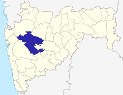
 Location of Adhala Dam in India Maharashtra | |
| Official name | Adhala Dam |
| Location | Akole, Deothan |
| Coordinates | 19°38′23″N 74°1′37″E / 19.63972°N 74.02694°ECoordinates: 19°38′23″N 74°1′37″E / 19.63972°N 74.02694°E |
| Construction began | 1966 |
| Opening date | 1976 |
| Owner(s) | Government of Maharashtra, India |
| Dam and spillways | |
| Type of dam | Earthfill |
| Impounds | Adhala river |
| Height | 40 m (130 ft) |
| Length | 623 m (2,044 ft) |
| Dam volume | 1,437 km3 (345 cu mi) |
| Reservoir | |
| Total capacity | 27,600 km3 (6,600 cu mi) |
| Surface area | 2,306 km2 (890 sq mi) |
Adhala Dam, is an earthfill dam on Adhala river near Akole,Deothan, Ahmednagar district in state of Maharashtra in India.
Specifications
The height of the dam above lowest foundation is 40 m (130 ft) while the length is 623 m (2,044 ft). The volume content is 1,437 km3 (345 cu mi) and gross storage capacity is 30,000.00 km3 (7,197.38 cu mi).[1]
- Capacity in TMC:1.06(By Abhi Thorat)
Purpose
- Irrigation in Akole,Sagamner & Sinner Tahsil
- Drinking Water supply to Devthan,Hivargaon Ambre, Ganore, Dongargaon & Pimplegaon villages (create by government)
See also
References
This article is issued from Wikipedia - version of the 8/5/2016. The text is available under the Creative Commons Attribution/Share Alike but additional terms may apply for the media files.
