al-Karmil
| al-Karmil | |
|---|---|
| Other transcription(s) | |
| • Arabic | خربة الكرمل |
| • Also spelled | Khirbat al-Karmil (official) |
|
Al-Karmil | |
  al-Karmil Location of al-Karmil within the Palestinian territories | |
| Coordinates: 31°25′25.19″N 35°07′59.37″E / 31.4236639°N 35.1331583°ECoordinates: 31°25′25.19″N 35°07′59.37″E / 31.4236639°N 35.1331583°E | |
| Palestine grid | 162/092 |
| Governorate | Hebron |
| Government | |
| • Type | Village council |
| Population (2007) | |
| • Jurisdiction | 3,741 |

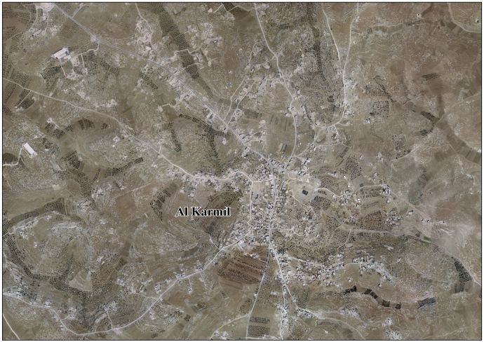
al-Karmil (Arabic: خربة الكرمل) is a Palestinian village located twelve kilometers south of Hebron. The village is in the Hebron Governorate Southern West Bank, within Area A under total Palestinian control.[1] According to the Palestinian Central Bureau of Statistics, the village had a population of 3,741 in 2007.[2] The primary health care facilities for the village are designated by the Ministry of Health as level 2.[3]
History
There are three references to al-Karmil in the Bible. "Carmel" is mentioned as a city of Judah, also as the place where Saul erects a monument after the expedition against the Amalek and where Nabal the Carmelite resides.[4][5][6][7]
In the Byzantine era, around the 6th or 7th century CE, a church was built here. In the 19th century, it was described as having three casemated arrow-slits on the east side.[8][9][10]
Al-Muqaddasi describes it 985 as "a village in the further limits of the Hebron territory, in Jund Filastin. This is the Carmel mentioned in Joshua xv.55."[11]
It was mentioned in Crusader sources in 1172/3,[12][13] as the place King Amalric of Jerusalem assembled his army.[10]
Ottoman era
In 1838 Edward Robinson noted here the remains of an ancient tower and an ancient church.[14]
In 1863, Victor Guérin visited, and noted the remains of an ancient church.[15]
In October 1874, the Palestine Exploration Fund's Survey of Western Palestine (SWP) found here extensive ruins, and a reservoir filled with water. Remains of a castle, possibly of Crusader origin, and a church were also found.[16]
The SWP also traced an ancient road from Jerusalem to Al-Karmil.[17]
Modern period
The population of the village was 146 in 1961.[18] In a census conducted by Israel after it occupied the West Bank in the Six-day War, the village was reported to have 76 residents in 17 households.[19]
The site contains an ancient reservoir, Birket Al-Karmel, which has been transformed into a major recreation area, with a swimming pool. Gideon Levy writes:
The terraces, decorative landscaping, Hebron stones, washrooms and a spring that gushes from the rock next to the pool – all make this one of the most spectacular outdoor sites in the West Bank.[1]
Twice, in 2015, settler tourists under IDF guard, made incursions into the park, after the army forced the local children out of the pool and allotted them to a corner while the settlers enjoyed the pool and the site.[1]
Footnotes
- 1 2 3 Gideon Levy and Alex Levac, 'Bitter waters: Settlers invade ancient pool under Palestinian control,' Haaretz 12 June 2015
- ↑ 2007 PCBS Census Palestinian Central Bureau of Statistics. p.120.
- ↑ West Bank Health care
- ↑ Joshua ch xv verse 55, 1 Samuel ch xv verse 12 and 1 Samuel ch xxv
- ↑ Nabal and Abigail
- ↑ Calmet's Dictionary of the Holy Bible, 1832. p 280
- ↑ Conder and Kitchener, 1883, SWP III, p. 312
- ↑ Rey, 1871, pp. 102-104
- ↑ Mader, 1918, pp. 177-185
- 1 2 Pringle, 1997, p. 61
- ↑ le Strange, 1890, pp. 487-8
- ↑ Guérin, 1869, p. 170
- ↑ Conder and Kitchener, 1883, SWP III, p. 372
- ↑ Robinson and Smith, 1841, vol 2, pp. 196-197
- ↑ Guérin, 1869, pp. 166-170
- ↑ Conder and Kitchener, 1883, SWP III, pp. 372-4
- ↑ Conder and Kitchener, 1883, SWP III, p. 317
- ↑ Government of Jordan, Department of Statistics (1964). First Census of Population and Housing. Volume I: Final Tables; General Characteristics of the Population. Table 1.8.
- ↑ Israel Central Bureau of Statistics (1967–1970). Joel Perlmann, ed. "The 1967 Census of the West Bank and Gaza Strip: A Digitized Version". Levy Economics Institute of Bard College, 2011–2012. Volume 1, Table 2.
Bibliography
- Conder, Claude Reignier; Kitchener, H. H. (1883). The Survey of Western Palestine: Memoirs of the Topography, Orography, Hydrography, and Archaeology. 3. London: Committee of the Palestine Exploration Fund.
- Guérin, Victor (1869). Description Géographique Historique et Archéologique de la Palestine (in French). 1: Judee, pt. 3. Paris: L'Imprimerie Nationale.
- Mader, Andreas (1918). Altchristliche Basiliken und Lokaltraditionen in Südjudäa. Archäologische und topographische Untersuchungen (in German). Paderborn: F. Schöningh.
- Murphy-O'Connor, Jerome (2008). The Holy Land: An Oxford Archaeological Guide from Earliest Times to 1700. Oxford University Press. ISBN 0-19-923666-6. ( p. 351)
- Palmer, E. H. (1881). The Survey of Western Palestine: Arabic and English Name Lists Collected During the Survey by Lieutenants Conder and Kitchener, R. E. Transliterated and Explained by E.H. Palmer. Committee of the Palestine Exploration Fund. (p. 403)
- Pringle, Denys (1997). Secular buildings in the Crusader Kingdom of Jerusalem: an archaeological Gazetter. Cambridge University Press. ISBN 0521 46010 7.
- Robinson, Edward; Smith, Eli (1841). Biblical Researches in Palestine, Mount Sinai and Arabia Petraea: A Journal of Travels in the year 1838. 2. Boston: Crocker & Brewster.
- Rey, E. G. (Emmanuel Guillaume) (1871). Etude sur les monuments de l'architecture militaire des croisés en Syrie et dans l'île de Chypre (in French). Paris: L'Imprimerie Nationale.
- Strange, le, Guy (1890). Palestine Under the Moslems: A Description of Syria and the Holy Land from A.D. 650 to 1500. Committee of the Palestine Exploration Fund.
External links
- Welcome To Khirbat al-Karmil
- Al Karmil Village (Fact Sheet)
- Al Karmil Village Profile
- Al Karmil Village aerial photo
- The priorities and needs for development in Al Karmil village based on the community and local authorities’ assessment
- Survey of Western Palestine, Map 21: IAA, Wikimedia commons

| Cities |
|   |
|---|---|---|
| Towns |
| |
| Villages |
| |
| Refugee camps | ||