Arkansas Highway 34
| ||||
|---|---|---|---|---|
 | ||||
| Route information | ||||
| Maintained by AHTD | ||||
| Length: | 40.18 mi[1] (64.66 km) | |||
| Existed: | 1926 – present | |||
| Major junctions | ||||
| West end: |
| |||
|
| ||||
| East end: |
| |||
| Location | ||||
| Counties: | Lawrence, Randolph, Greene, | |||
| Highway system | ||||
| ||||

Highway 34 (AR 34, Ark. 34, and Hwy. 34) is an east–west state highway in the Upper Arkansas Delta. The route of 40.18 miles (64.66 km) begins at US Highway 412 (US 412) and US Highway 67 Business (US 67B). The route is maintained by the Arkansas State Highway and Transportation Department (AHTD).[2][3][4]
Route description
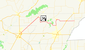
AR 34 begins in Walnut Ridge and runs northeast under US 67, meeting and concurring with AR 231 until O'Kean. AR 34 meets AR 90 in O'Kean, and runs with it northeast to Delaplaine. The route turns south in Delaplaine to Evening Star, when it heads east to meet AR 141 in Beech Grove. AR 34 continues east to meet AR 135 north of Oak Grove Heights, which it follows north until Lafe. AR 34 then runs east to Marmaduke, where it crosses US 49/AR 1. The route continues east to the community of Fritz, where AR 34 meets AR 139 and terminates.
History
Highway 34 is one of the original 1926 Arkansas state highways.
Major intersections
| County | Location | mi | km | Destinations | Notes |
|---|---|---|---|---|---|
| Lawrence | Walnut Ridge | 0.00 | 0.00 | Eastern terminus | |
| 1.24 | 2.00 | ||||
| Giles | 5.77 | 9.29 | |||
| Randolph | O'Kean | 10.58 | 17.03 | West end of AR 90 overlap | |
| Greene | Delaplaine | 0.00 | 0.00 | East end of AR 90 overlap | |
| Beech Grove | 9.31 | 14.98 | |||
| Oak Grove Heights | 16.64 | 26.78 | West end of AR 135 overlap | ||
| Lafe | 0.00 | 0.00 | East end of AR 135 overlap | ||
| Marmaduke | 7.36 | 11.84 | |||
| Fritz | 12.96 | 20.86 | Eastern terminus | ||
1.000 mi = 1.609 km; 1.000 km = 0.621 mi
| |||||
See also
-
 Arkansas portal
 -
 U.S. Roads portal
References
- ↑ Planning and Research Division (March 28, 2012). "Arkansas Road Log Database" (MBD). Arkansas State Highway and Transportation Department. Retrieved April 13, 2012.
- ↑ General Highway Map, Lawrence County, Arkansas (PDF) (Map). 1:62500. Cartography by Transportation Planning & Policy Division. Little Rock: Arkansas State Highway and Transportation Department. 2008-01-22. Retrieved 2016-07-22.
- ↑ General Highway Map, Randolph County, Arkansas (PDF) (Map). 1:62500. Cartography by Transportation Planning & Policy Division. Little Rock: Arkansas State Highway and Transportation Department. 2008-05-12. Retrieved 2016-07-22.
- ↑ General Highway Map, Greene County, Arkansas (PDF) (Map). 1:62500. Cartography by Transportation Planning & Policy Division. Little Rock: Arkansas State Highway and Transportation Department. 2015-02-17. Retrieved 2016-07-22.
