Baía Formosa
| Baía Formosa | |
|---|---|
| Municipality | |
| The Municipality of Baía Formosa | |
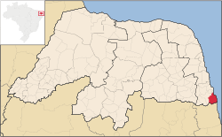 Location of Baía Formosa | |
| Coordinates: 06°22′08″S 35°00′28″W / 6.36889°S 35.00778°WCoordinates: 06°22′08″S 35°00′28″W / 6.36889°S 35.00778°W | |
| Country |
 Brazil Brazil |
| Region | Northeast |
| State |
 Rio Grande do Norte Rio Grande do Norte |
| Founded | December 31, 1958 |
| Government | |
| • Mayor | José Nivaldo Araújo de Melo |
| Area | |
| • Total | 245.510 km2 (94.792 sq mi) |
| Population (2008) | |
| • Total | 8,726 |
| • Density | 33.7/km2 (87/sq mi) |
| [1] | |
| Time zone | UTC-3 |
| HDI (2000) | 0.643 – medium[2] |
Baía Formosa (lit. "beautiful bay") is the easternmost city in the Brazilian state of Rio Grande do Norte. It is also the first coastal city (going south-north) of that state, lying near the border with Paraíba.
The municipality contains the 7,897 hectares (19,510 acres) Mata da Estrela Private Natural Heritage Reserve.[3]
References
- ↑ IBGE 2008 statistics
- ↑ "Archived copy". Archived from the original on 2009-10-03. Retrieved 2009-12-17. - UNDP
- ↑ RPPN Mata Estrela (in Portuguese), ICMBio, retrieved 2016-05-18
This article is issued from Wikipedia - version of the 10/29/2016. The text is available under the Creative Commons Attribution/Share Alike but additional terms may apply for the media files.