Bat's Head

View west towards Bat's Head with the Isle of Portland in the distance.
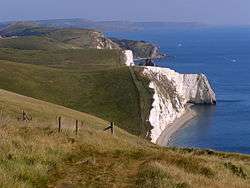
View east towards Bat's Head from White Nothe.
Bat's Head is a chalk headland on the Dorset coast in southern England, located between Swyre Head and Durdle Door to the east, and Chaldon Hill and White Nothe to the west.[1][2]
There is a small but very visible cave at the base of the headland known as Bat's Cave. A spectacular path, part of the South West Coast Path, runs along the coast through rolling green downland countryside to the north of Bat's Head.
References
- ↑ Ordnance Survey: Landranger map sheet 194 Dorchester & Weymouth (Cerne Abbas & Bere Regis) (Map). Ordnance Survey. 2014. ISBN 9780319232132.
- ↑ "Ordnance Survey: 1:50,000 Scale Gazetteer" (csv (download)). www.ordnancesurvey.co.uk. Ordnance Survey. 1 January 2016. Retrieved 30 January 2016.
See also
- List of places on the Jurassic Coast
External links
Coordinates: 50°37′22″N 2°17′28″W / 50.6227°N 2.2910°W
This article is issued from Wikipedia - version of the 2/1/2016. The text is available under the Creative Commons Attribution/Share Alike but additional terms may apply for the media files.