Bath Covered Bridge
|
Bath Covered Bridge | |
|
Bath Covered Bridge in 2010 | |
  | |
| Location | Off US 302, NH 10, Bath, New Hampshire |
|---|---|
| Coordinates | 44°10′1″N 71°58′3″W / 44.16694°N 71.96750°WCoordinates: 44°10′1″N 71°58′3″W / 44.16694°N 71.96750°W |
| Area | 0.3 acres (0.12 ha) |
| Built | 1832 |
| Architectural style | Burr truss |
| NRHP Reference # | 76000125[1] |
| Added to NRHP | September 01, 1976 |
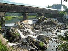
The Bath Covered Bridge is a historic covered bridge over the Ammonoosuc River off US 302 and NH 10 in Bath, New Hampshire. The bridge, built in 1833 by the town of Bath, has a span of over 390 feet (120 m) and a roadbed that is just over 22 feet (6.7 m) wide. The bridge consists of four spans supported by Burr trusses. When originally built, it had only three spans, but when the bridge was raised in the 1920s, a third pier was added, as were laminated arches to strengthen the bridge.[2]
The bridge was listed on the National Register of Historic Places in 1976.[1]
The bridge was closed to traffic in October 2012[3] for safety, structural, and cosmetic reasons.[4] After 21 months and $3 million in repairs, it re-opened in August 2014.[3]
See also
- List of bridges on the National Register of Historic Places in New Hampshire
- List of covered bridges in New Hampshire
- National Register of Historic Places listings in Grafton County, New Hampshire
References
- 1 2 National Park Service (2009-03-13). "National Register Information System". National Register of Historic Places. National Park Service.
- ↑ "NRHP nomination for Bath Covered Bridge" (PDF). National Park Service. Retrieved 2014-03-18.
- 1 2 Tracy, Paula (13 August 2014). "Longest covered bridge in NH set to reopen Thursday". WMUR9. Retrieved 29 November 2016.
- ↑ Hookway, Bob (27 Jan 2013). "Bath covered bridge closes for restoration". New Hampshire Union Leader. Retrieved 29 November 2016.
External links
| Wikimedia Commons has media related to Bath Bridge (Bath, New Hampshire). |
- Historic American Engineering Record (HAER) No. NH-34, "Bath Bridge, Spanning Ammonoosuc River, Lisbon Road, Bath, Grafton County, NH"
| Topics | |
|---|---|
| Lists by states |
|
| Lists by insular areas | |
| Lists by associated states | |
| Other areas | |
| |
This article is issued from Wikipedia - version of the 11/29/2016. The text is available under the Creative Commons Attribution/Share Alike but additional terms may apply for the media files.