Battery Rocks
Battery Rocks (grid reference SW477298) are a rocky headland situated to the south of the harbour of Penzance, Cornwall, England, UK.[1] The rocks take their name from a gun battery that was situated there from 1739, following a petition by Penzance Borough council for protection from French naval attacks.
History
Of the Battery, Craig Weatherhill, local historian and archaeologist wrote:
"The 18th century gun battery site is in fact a good deal older than that and is almost certainly the site mentioned in the report to King Philip of Spain written by Don Carlos de Amezola, commanding officer of the fleet of four Spanish warships that raided Mousehole, Newlyn and Penzance in August 1595.
Captain de Amezola wrote the following words in this report:
‘At the same time, the sergeant major Juan de Arnica, on the order of Captain Carlos de Amezola, went with twelve musketeers and arquebusiers in a launch to capture the piece of artillery that was in the fort in Penzance. Although there were English (sic) men who came to its defence, the sergeant major got the piece on board and brought it to the flagship’. No other gun battery site is known on the coast at Penzance and this is almost certainly the Battery Rocks site that is the subject of this report. "
Geography
Battery Rocks and the adjacent tidal beach, a favourite local spot, are an integral part of the Pen Sans--Holy Headland--after which Penzance is named.
Battery Rocks have been a favourite location for local swimmers for as long as can be remembered, even at the heart of winter! They are also home to a variety of wildlife including a colony of rare purple sandpipers.
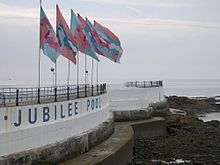
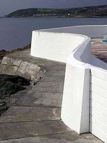
The Rocks are the setting for the Penzance war memorial and the restored Grade II Listed Jubilee Pool, an art deco lido, one of the very few surviving--described in the listing notes as one of the finest examples.
In 2009 The Battery Rocks came under threat from the "Route Partnership" scheme, which intended to transform this tranquil location into a freight yard. It became the subject of much local campaigning, however despite objections the controversial scheme achieved planning consent. Ultimately the project was halted by the Dept of Transport who refused to fund the project.
References
- ↑ Ordnance Survey Explorer 7; Land's End, Penzance and St. Ives, 1:25 000 scale. 1996
Cornwall Portal | |
| Unitary authorities | |
| Major settlements |
|
| Rivers | |
| Topics | |
Coordinates: 50°06′52″N 5°31′50″W / 50.11455°N 5.53047°W