Beacon Valley

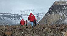
Researchers trek through Antarctica's Beacon Valley, one of the most Mars-like places on Earth. Image credit: NASA
Beacon Valley (77°49′S 160°39′E / 77.817°S 160.650°ECoordinates: 77°49′S 160°39′E / 77.817°S 160.650°E) is an ice-free valley between Pyramid Mountain and Beacon Heights, in Victoria Land. It was mapped by the British Antarctic Expedition, 1910–13, and named by the Victoria University of Wellington Antarctic Expedition (VUWAE) (1958–59) after Beacon Heights.
Astrobiological Characteristics
The central region of Beacon valley is considered to be one of the best terrestrial analogues for the current conditions on Mars. There is snowdrift and limited melting around the edges and occasionally in the central region, but for the most part, moisture is only found as thin films of brine around permafrost structures. It has slightly alkaline salt rich soil.[1][2]
References
- ↑ McKay, Christopher P. (2008). "Snow recurrence sets the depth of dry permafrost at high elevations in the McMurdo Dry Valleys of Antarctica" (PDF). Antarctic Science. 21 (01): 89. doi:10.1017/S0954102008001508. ISSN 0954-1020.
- ↑ The Planetary and Space Sciences Research Institute, The Open University (5 December 2012). "TN2: The Catalogue of Planetary Analogues, section 1.6.3" (PDF). Under ESA contract: 4000104716/11/NL/AF.
-
 This article incorporates public domain material from the United States Geological Survey document "Beacon Valley" (content from the Geographic Names Information System).
This article is issued from Wikipedia - version of the 10/29/2016. The text is available under the Creative Commons Attribution/Share Alike but additional terms may apply for the media files.