Bears Tooth
| Bears Tooth | |
|---|---|
 The Bears Tooth | |
| Highest point | |
| Elevation | 11,920 ft (3,630 m) [1] |
| Prominence | 315 ft (96 m) [1] |
| Coordinates | 45°03′46″N 109°33′45″W / 45.06278°N 109.56250°WCoordinates: 45°03′46″N 109°33′45″W / 45.06278°N 109.56250°W [2] |
| Geography | |
 Bears Tooth Carbon County, Montana, U.S. | |
| Parent range | Beartooth Mountains |
| Topo map | USGS Silver Run Peak |
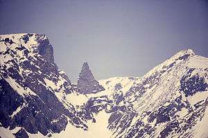
Bears Tooth (11,920 feet (3,630 m)) is a mountain spire in the Beartooth Mountains in the U.S. state of Montana.[3] The peak is in the Absaroka-Beartooth Wilderness in Custer National Forest, and is adjacent to Beartooth Mountain. Bears Tooth is a spire and is the namesake for numerous other points in the region and the Beartooth Mountains themselves. Known by the Native American Crow as "Na Piet Say", translated as bears tooth, the spire can be seen from the Beartooth Highway.[4]
References
- 1 2 "Bears Tooth, Montana". Peakbagger.com. Retrieved October 31, 2016.
- ↑ "Bears Tooth". Geographic Names Information System. United States Geological Survey. Retrieved October 31, 2016.
- ↑ Alpine, MT (Map). TopoQwest (United States Geological Survey Maps). Retrieved October 31, 2016.
- ↑ "Driving the Beartooth Highway". Bozeman Magazine. August 1, 2013. Retrieved October 31, 2016.
This article is issued from Wikipedia - version of the 10/31/2016. The text is available under the Creative Commons Attribution/Share Alike but additional terms may apply for the media files.