Bethel Air Base
| Bethel Air Base | |||||||||||||||||||
|---|---|---|---|---|---|---|---|---|---|---|---|---|---|---|---|---|---|---|---|
 | |||||||||||||||||||
| IATA: none – ICAO: none | |||||||||||||||||||
| Summary | |||||||||||||||||||
| Airport type | Military | ||||||||||||||||||
| Owner | United States Army | ||||||||||||||||||
| Location | Bethel, Alaska | ||||||||||||||||||
| Elevation AMSL | 129 ft / 39 m | ||||||||||||||||||
| Coordinates | 60°46′43″N 161°50′14″W / 60.77861°N 161.83722°WCoordinates: 60°46′43″N 161°50′14″W / 60.77861°N 161.83722°W | ||||||||||||||||||
| Map | |||||||||||||||||||
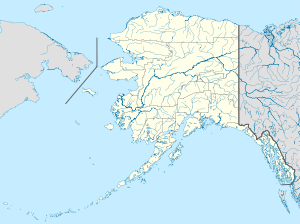  Bethel AB Location of airport in Alaska | |||||||||||||||||||
| Runways | |||||||||||||||||||
| |||||||||||||||||||
Bethel Air Base is a former United States Army airfield located three nautical miles (6 km) southwest of the central business district of Bethel, a city in the Bethel Census Area of the U.S. state of Alaska.[1]
History
Construction began September 21, 1941, and the airfield was activated July 4, 1942. It was used by Air Transport Command as auxiliary airfield for Lend-Lease aircraft being flown to Siberia. The facility was transferred to Eleventh Air Force, then to Alaskan Air Command in 1945; it became the joint-use Bethel Airport. It was used for construction of AC&W Bethel Air Force Station in the mid-1950s. Full jurisdiction was turned over to Alaska Government in 1958.[2]
See also
References
- 1 2 FAA Airport Master Record for BET (Form 5010 PDF). Federal Aviation Administration. Effective May 31, 2012.
- ↑
 This article incorporates public domain material from the Air Force Historical Research Agency website http://www.afhra.af.mil/.
Previously: Alaskan Air Force (1941-1942) | |||||||||||||
| Bases |
| .svg.png) | |||||||||||
| Units |
| ||||||||||||

This article is issued from Wikipedia - version of the 9/27/2015. The text is available under the Creative Commons Attribution/Share Alike but additional terms may apply for the media files.