Lake Moeris
Coordinates: 29°27′13″N 30°34′51″E / 29.45361°N 30.58083°E

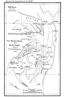
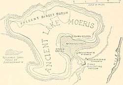
Lake Moeris (Ancient Greek: Μοῖρις, genitive Μοίριδος) is an ancient lake in the northwest of the Faiyum Oasis, 80 km (50 mi) southwest of Cairo, Egypt. In prehistory, it was a freshwater lake, with an area estimated to vary between 1,270 km2 (490 sq mi) and 1,700 km2 (660 sq mi).
It persists today as a smaller saltwater lake called Birket Qarun. The lake's surface is 43 metres (141 ft) below sea level, and covers about 202 km2 (78 sq mi).
It is a source for tilapia and other fish from the local area.
The prehistoric mammal Moeritherium was found in this area.
History


When the Mediterranean Sea was a hot dry hollow near the end of the Messinian Salinity Crisis in the late Miocene, Faiyum was a dry hollow, and the Nile flowed past it at the bottom of a canyon, 2,400 metres (7,900 ft) deep or more where Cairo is now. After the Mediterranean reflooded at the end of the Miocene, the Nile canyon became an arm of the sea reaching inland further than Aswan.
Over geological time that sea arm gradually filled with silt and became the Nile valley.
Eventually, the Nile valley bed silted up high enough to let the Nile in flood overflow into the Faiyum hollow and make a lake in it. As it was bordered by neolithic settlements there was likely a reliable potable water supply. The town of Shedet grew up on the south where the higher ground created a ridge, suggesting lake water levels varied widely, making it unwise to build on flatter ground.
The lake plays an intimate part in the history of the Old Kingdom of Egypt, being first recorded in about 3000 BC, around the time of Menes (Narmer) who is credited with unifying Egypt's Upper and Lower Kingdoms. For the most part the lake would only be filled with high flood waters, so its mention may suggest preventing excess flooding was a political goal from that time.
Oral history of the Fourth Dynasty of Egypt holds that canals or aqueducts ran from the lake to the Giza pyramid complex and thence to the Sphinx and back to the Nile. The Ur Nile, just northeast of the complex, was another such source. As the lake was mostly or only filled with flood waters when there was a need to divert not add water to the Nile, to be useful such water had to be retained in the lake by locks, pumped up by underground water tables or held in reservoirs near the complex. Corresponding retaining walls have been found around the Great Pyramid, and an offset square hole in its subterranean chamber leads to a tunnel that (the angle and other evidence suggests) may have exited near the Sphinx. Both the chamber and the Sphinx show signs of water wear. No competing theory explains how large amounts of water could reach Giza for construction purposes, for a large labor force to drink in arid conditions, or to grow food. Entrance height of the Great Pyramid of Giza also corresponds to a likely aqueduct and moat height - a retaining wall having been verifiably part of the original Pyramid, but destroyed over centuries as it was mostly dismantled for building stones. Contemporaneous oral history holds the Pyramid was a machine with sonic properties – a claim unexplained until the 21st century, though backed by evidence of resonances in its chambers, such as the 440Hz of the "King's Chamber" sarcophagus.
Any aqueducts or canals to the lake are lost, but there is other evidence of large reservoir pumping: Working models prove the subterranean chambers in the Great Pyramid of Giza would act – given a large enough water feed – as a highly efficient hydraulic ram pump. Working scale models (by John Cadman[1]) proved the design was about twice as efficient as simple ram pump. Such a purpose justifies the unusual engineering exactness of the building. The pump operates with a heartbeat-like resonance that amplifies given acoustic properties of the chambers in the built portion, but this resonance is unnecessary for pumping based on gravity action alone - decreasing its efficiency when it is run by gravity fed water alone. Nearby were found "lotus vases" of volcanic rock that resemble modern impellers and other hydraulic parts, unusually exact, that appear to be "machined". Accordingly the working Pyramid pump may have had unexplained control or efficiency features that regulated flow between Lake Moeris, subterranean water table, surface or covered reservoirs, and the Nile. Any powerful and mysterious technology would enable claims of divine power and of flood control, are first recorded around this time. This suggests the theocracy likely controlled the water flow.
Regardless of mechanism, the lake and underground reservoirs are the only feasible water sources for the Giza Plateau, so without pumping, the lake must have supplied larger aqueducts and locks, and larger reservoirs protected from evaporation and contamination, than with an efficient pump.
Other evidence establishes the lake as the subject of other major diversion projects, and a key Nile control. In 2300 BC, during the Sixth Dynasty of Egypt (2345–2181 BC), the waterway from the Nile to the natural lake was widened and deepened to make a canal which is now known as the Bahr Yussef. This project was started by Amenemhat III, or perhaps by his father Senusret III. This canal fed into the lake. This was meant to serve three purposes: control the flooding of the Nile, regulate the water level of the Nile during dry seasons, and serve the surrounding area with irrigation. The 22nd century BC drought very drastically cut precipitation between 2200 and 2150 BC and prevented normal Nile flooding [2] which collapsed that Dynasty, ended the Old Kingdom, and brought famine. Evidently the lake waterworks could not cope with such an extreme, so unusual it is referred to as "the 4.2 kiloyear event".
Later dynasties apparently lost the most sophisticated large scale aqueduct, reservoir or pump technology, not unusual in a social catastrophe, but continued to use simpler canal technology to regulate the Nile. Large scale waterworks are in evidence from the Twelfth dynasty of Egypt, using the natural lake of Faiyum as a reservoir to store surpluses of water for use during the dry periods, as had been long believed to have been done in the Fourth Dynasty of Egypt and a function served by the Giza pyramid complex. The immense waterworks undertaken to transform the lake into a huge water reservoir gave the impression that the lake was an artificial excavation, as reported by classic geographers and travellers.[3] The lake was eventually abandoned due to the nearest branch of the Nile shrinking from 230 BC.
Etymology
| |||
| mer-wer (Moeris) in hieroglyphs |
|---|
The name Moeris is a Greek version (reformed as if from Greek Μοῖραι "the Fates") from Egyptian mer-wer ‘great canal’. Amenemhat III, who started this project, was also known as Moeris. In ancient Egypt, the lake was also variously called ‘the lake’, ‘pure lake’, and ‘Osiris's lake’. During the Middle Kingdom, the whole area around the lake was often referred to as mer-wer also. Similarly, the Late Egyptian word Piom ‘sea’, originally restricted to Lake Moeris, came to be used to refer to the city of Crocodilopolis (mod. Faiyum), then to the entire region in later times.
See also
- Bahr Yussef
- Faiyum
- Faiyum Governorate
- Faiyum Oasis
- Moeritherium, an ancient relative of elephants whose fossils were found in the region.
Notes
- ↑
- ↑ Jean-Daniel Stanley; et al. (2003). "Nile flow failure at the end of the Old Kingdom, Egypt: Strontium isotopic and petrologic evidence". Geoarchaeology. 18 (3): 395–402. doi:10.1002/gea.10065.
- ↑
 Hyvernat, Eugène Xavier Louis Henri (1913). "Egypt". In Herbermann, Charles. Catholic Encyclopedia. New York: Robert Appleton Company.
References
Attribution
-
 This article incorporates text from a publication now in the public domain: Griffith, Francis Llewellyn (1911). "Moeris, Lake of". In Chisholm, Hugh. Encyclopædia Britannica (11th ed.). Cambridge University Press.
External links
-
 "Mœris". Encyclopedia Americana. 1920.
 -
 "Mœris". The American Cyclopædia. 1879.