Bo Rai District
| Bo Rai บ่อไร่ | |
|---|---|
| Amphoe | |
 | |
 Amphoe location in Trat Province | |
| Coordinates: 12°34′47″N 102°31′30″E / 12.57972°N 102.52500°ECoordinates: 12°34′47″N 102°31′30″E / 12.57972°N 102.52500°E | |
| Country |
|
| Province | Trat |
| Seat | Bo Phloi |
| Area | |
| • Total | 680.0 km2 (262.5 sq mi) |
| Population (2000) | |
| • Total | 39,736 |
| • Density | 58.4/km2 (151/sq mi) |
| Time zone | THA (UTC+7) |
| Postal code | 23140 |
| Geocode | 2304 |
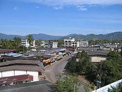
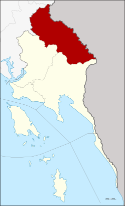
Bo Rai (Thai: บ่อไร่, pronounced [bɔ̀ː râj]) is a township and district (Amphoe) located in Trat Province, Eastern Thailand, in close vicinity to the Cambodian Khao Banthat Mountain Range. Neighboring districts are Mueang Trat and Khao Saming to the south, Khlung of Chanthaburi Province to the west, Pong Nam Ron of Chanthaburi to the north, and Battambang of Cambodia to the north and east.
Administration
Amphoe Bo Rai is divided into five subdistricts (tambon), which are further subdivided into 34 villages (muban). The central town is Bo Phloi, which has township status (thesaban tambon) and covers parts of the same-named tambon. As of 2005, the population in the township is 10,009. Each of the tambon is administrated by a Tambon administrative organization (TAO).
|

History
The area is renowned for its gemstone mining (rubies and sapphires) and gem trade which made Bo Rai prosper and grow. From the 1960s until the beginning of the 1990s the town experienced an economic boom, which was ended almost overnight with the exhaustion of the mining fields through plundering. The economic depression that followed was further increased by the downfall of the Khmer Rouge and the subsequent end of the border trafficking of goods and gems.
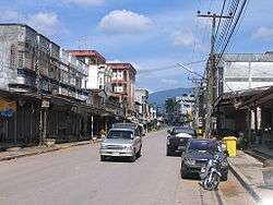
Once the centre of Thailand's gem trade, Bo Rai is now but a shadow of its former glory, yet some hope is seen in the migrating refugees coming from the troubled South. There have been attempts at economic conversion, such as the cultivation of rubber trees. There are rumours of a new Thai-Cambodian border crossing being opened in the near future, a thing welcomed and hoped for by the local population.
Quite recently, the town has had newcomers settling down and opening new businesses and the once rundown merchant houses are open again. The new mayor has had a reviving effect on the town, a new project called Bor Ploy Health Club has been opened close to Dan Chumphon - Saen Tung road intersection.

Sights
There is a big Buddhist temple in the city called Wat Bo Phloi and a brand new Fresh-food Market Talat Sot opened just 2006 . On Wednesdays there is a Talat Nat (weekly market), with vendors coming from as far as the neighbouring Cambodia. There is a public park Suan Sukkhaphap, a hospital, many schools, a public library as well as an astonishing number of beauty parlours scattered all over town. At the time of writing there are two motels in town.
About nine kilometres from the town, there is a tiny but well kept National Park called Namtok Khlong Kaeo (Thai น้ำตกคลองแก้ว). Admission is 100 Bath for foreigners. A paved path leads up to the source of the waterfall, about 800 metres above sea level. The visitor is rewarded with a stunning view over the landscape with groves and rubber plantations as far as the eye can see.

Location and Directions
Bo Rai seems to be faraway from everywhere: 50 kilometres from Trat (route 3157 via Dan Chumphon), 90 kilometres from Chanthaburi (via Saen Tung), and 450 kilometres from Bangkok. The shortest route to Bo Rai is from Highway 3 through Khao Saming (route 3159). There is a public transport service by songthaew from Trat and Chanthaburi. Apart from day time baht buses, no regular bus route is currently available.
Places
- Bo Phloi town: 12°34′17″N 102°32′18″E / 12.57139°N 102.53833°E
- Namtok Khlong Kaeo National Park: 12°37′05″N 102°34′39″E / 12.618065°N 102.577597°E