Brigham railway station
| Brigham | |
|---|---|
|
The station in 1961 | |
| Location | |
| Place | Brigham |
| Area | Allerdale |
| Coordinates | 54°39′57″N 3°25′14″W / 54.66574°N 3.42058°WCoordinates: 54°39′57″N 3°25′14″W / 54.66574°N 3.42058°W |
| Grid reference | NY085310 |
| Operations | |
| Original company | Cockermouth & Workington Railway |
| Pre-grouping | London and North Western Railway |
| Post-grouping | London, Midland and Scottish Railway |
| Platforms | 3[1] |
| History | |
| 28 April 1847 | Opened |
| 18 April 1966 | Closed[2] |
| Disused railway stations in the United Kingdom | |
|
Closed railway stations in Britain A B C D–F G H–J K–L M–O P–R S T–V W–Z | |
|
| |
_Station_1906983_1c110717.jpg)
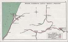
| Cockermouth and |
|---|
Legend |
Brigham railway station was situated on the Cockermouth and Workington Railway and served the village of Brigham, Cumbria, England.[3][4]
History
A 1904 Railway Clearing House Junction Diagram showing (right) railways in the vicinity of the station
The station opened on 28 April 1847 and closed on 18 April 1966. The last train was the 20:19 DMU from Keswick to Workington Main on Saturday 16 April.[5]
Afterlife
In 2013 remains of the station and the junction to Papcastle station were still visible by the A66 road before the Great Broughton junction; most of this track now forms part of the A66.
| Preceding station | Disused railways | Following station | ||
|---|---|---|---|---|
| Cockermouth (C&W) 1847-65 |
Cockermouth & Workington Railway | Broughton Cross Line and station closed | ||
| Cockermouth 1865-1966 |
London and North Western Railway Cockermouth, Keswick and Penrith Railway |
Broughton Cross Line and station closed | ||
| Cockermouth Reversed at Brigham |
Maryport and Carlisle Railway | Papcastle Line and station closed | ||
See also
References
- ↑ Marsh & Garbutt 1999, p. 141.
- ↑ Butt 1995, p. 44.
- ↑ Smith & Turner 2012, Map 26.
- ↑ Jowett 2000, Map 36.
- ↑ Suggitt 2008, p. 81.
Sources
- Butt, R. V. J. (1995). The Directory of Railway Stations: details every public and private passenger station, halt, platform and stopping place, past and present (1st ed.). Sparkford: Patrick Stephens Ltd. ISBN 1-8526-0508-1. OCLC 60251199.
- Jowett, Alan (March 1989). Jowett's Railway Atlas of Great Britain and Ireland: From Pre-Grouping to the Present Day (1st ed.). Sparkford: Patrick Stephens Ltd. ISBN 1-8526-0086-1. OCLC 22311137.
- Marsh, John; Garbutt, John (1999). Cumbrian Railways. Alan Sutton Publishing Ltd. ISBN 0750920432.
- Smith, Paul; Turner, Keith (2012). Railway Atlas Then and Now. Ian Allan Publishing. ISBN 978 0 7110 3695 6.
- Suggitt, Gordon (2008). Lost Railways of Cumbria (Railway Series). Newbury: Countryside Books. ISBN 978-1-84674-107-4.
Further reading
- British Railways Pre-Grouping Atlas And Gazetteer. Shepperton: Ian Allan Publishing. 1997 [1958]. ISBN 0-7110-0320-3.
- Anderson, Paul (April 2002). Hawkins, Chris, ed. "Dog in the Manger? The Track of the Ironmasters". British Railways Illustrated. Clophill: Irwell Press Ltd. 11 (7).
- Bairstow, Martin (1995). Railways In The Lake District. Martin Bairstow. ISBN 1-871944-11-2.
- Bowtell, Harold D. (1989). Rails through Lakeland: An Illustrated Journey of the Workington-Cockermouth-Keswick-Penrith Railway 1847-1972. Wyre, Lancashire: Silverling Publishing Ltd. ISBN 0-947971-26-2.
- Joy, David (1983). Lake Counties (Regional History of the Railways of Great Britain). Newton Abbot: David & Charles. ISBN 094653702X.
- McGowan Gradon, W. (2004) [1952]. The Track of the Ironmasters: A History of the Cleator and Workington Junction Railway. Grange-over-Sands: Cumbrian Railways Association. ISBN 0-9540232-2-6.
- Marshall, John (1981). Forgotten Railways: North West England. Newton Abbot: David & Charles. ISBN 0 7153 8003 6.
- Western, Robert (2001). The Cockermouth, Keswick and Penrith Railway OL113. Usk: Oakwood Press. ISBN 0-85361-564-0.
External links
- Map of the line with photos, via RAILSCOT
- The station on an OS map surveyed in 1864, via National Library of Scotland
- The station on overlain OS maps surveyed from 1898, via National Library of Scotland
- The station on a 1948 OS Map, via npe maps
- The station, via Rail Map Online
- The railways of Cumbria, via Cumbrian Railways Association
- Photos of Cumbrian railways, via Cumbrian Railways Association
- The railways of Cumbria, via Railways_of_Cumbria
- Cumbrian Industrial History, via Cumbria Industrial History Society
- Local history of the CKPR route, via Cockermouth
- The line's and station's Engineer's Line References, via railwaycodes.org.uk
- A video tour-de-force of the region's closed lines, via cumbriafilmarchive
This article is issued from Wikipedia - version of the 11/8/2016. The text is available under the Creative Commons Attribution/Share Alike but additional terms may apply for the media files.