Brooklyn (village), Wisconsin
| Brooklyn (village), Wisconsin | |
|---|---|
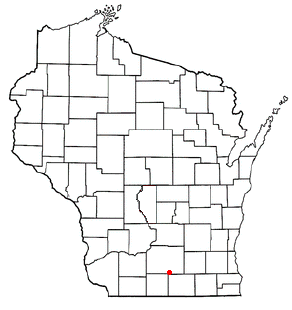
 Location in Dane County and the state of Wisconsin. | |
| Area[1] | |
| • Total | 1.09 sq mi (2.82 km2) |
| • Land | 1.09 sq mi (2.82 km2) |
| • Water | 0 sq mi (0 km2) |
| Population (2010)[2] | |
| • Total | 1,401 |
| • Estimate (2012[3]) | 1,436 |
| • Density | 1,285.3/sq mi (496.3/km2) |
| Website |
brooklynwi |


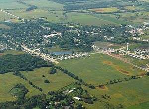
Brooklyn is a village in Dane and Green Counties in the U.S. state of Wisconsin. At the 2000 census, 502 Brooklyn residents lived in Dane County, and 414 in Green County, with a total population of 916. The 2010 census population was 1,401 inhabitants, with 936 of these in Dane County, and 465 in Green County.
The Dane County portion of Brooklyn is part of the Madison Metropolitan Statistical Area, while the Green County portion is part of the Monroe Micropolitan Statistical Area.
History
The village was incorporated in 1905. It was named after Brooklyn, New York.[4]
Geography
Brooklyn is located at 42°51′13″N 89°22′11″W / 42.853600°N 89.369689°WCoordinates: 42°51′13″N 89°22′11″W / 42.853600°N 89.369689°W.[5]
According to the United States Census Bureau, the village has a total area of 1.09 square miles (2.82 km2), all of it land.[1]
All mailing addresses in the village use ZIP code 53521.
The village straddles the boundary between the Sugar-Pecatonica river basin (Allen Creek and Middle Sugar River watershed) draining to the west, and Lower Rock river basin (Badfish Creek watershed) draining to the east.
Demographics
| Historical population | |||
|---|---|---|---|
| Census | Pop. | %± | |
| 1910 | 362 | — | |
| 1920 | 407 | 12.4% | |
| 1930 | 406 | −0.2% | |
| 1940 | 449 | 10.6% | |
| 1950 | 479 | 6.7% | |
| 1960 | 590 | 23.2% | |
| 1970 | 565 | −4.2% | |
| 1980 | 627 | 11.0% | |
| 1990 | 789 | 25.8% | |
| 2000 | 916 | 16.1% | |
| 2010 | 1,401 | 52.9% | |
| Est. 2015 | 1,449 | [6] | 3.4% |
2010 census
As of the census[2] of 2010, there were 1,401 people, 508 households, and 391 families residing in the village. The population density was 1,285.3 inhabitants per square mile (496.3/km2). There were 527 housing units at an average density of 483.5 per square mile (186.7/km2). The racial makeup of the village was 95.1% White, 2.0% African American, 0.1% Native American, 0.6% Asian, 1.1% from other races, and 1.1% from two or more races. Hispanic or Latino of any race were 5.9% of the population.
There were 508 households of which 46.1% had children under the age of 18 living with them, 60.4% were married couples living together, 9.6% had a female householder with no husband present, 6.9% had a male householder with no wife present, and 23.0% were non-families. 15.9% of all households were made up of individuals and 5.3% had someone living alone who was 65 years of age or older. The average household size was 2.76 and the average family size was 3.11.
The median age in the village was 32.8 years. 30% of residents were under the age of 18; 6.3% were between the ages of 18 and 24; 34.9% were from 25 to 44; 23.4% were from 45 to 64; and 5.6% were 65 years of age or older. The gender makeup of the village was 50.4% male and 49.6% female.
2000 census
As of the census[8] of 2000, there were 916 people, 343 households, and 255 families residing in the village. The population density was 837.4 people per square mile (324.5/km²). There were 351 housing units at an average density of 320.9 per square mile (124.3/km²). The racial makeup of the village was 98.25% White, 0.22% African American, 0.44% Asian, 0.33% from other races, and 0.76% from two or more races. Hispanic or Latino of any race were 1.42% of the population.
There were 343 households out of which 43.1% had children under the age of 18 living with them, 60.3% were married couples living together, 9.0% had a female householder with no husband present, and 25.4% were non-families. 18.7% of all households were made up of individuals and 8.7% had someone living alone who was 65 years of age or older. The average household size was 2.67 and the average family size was 3.08.
In the village the population was spread out with 30.1% under the age of 18, 5.9% from 18 to 24, 39.0% from 25 to 44, 16.6% from 45 to 64, and 8.4% who were 65 years of age or older. The median age was 33 years. For every 100 females there were 104.0 males. For every 100 females age 18 and over, there were 104.5 males.
The median income for a household in the village was $48,056, and the median income for a family was $51,607. Males had a median income of $34,934 versus $25,893 for females. The per capita income for the village was $19,480. About 1.1% of families and 2.9% of the population were below the poverty line, including 1.5% of those under age 18 and 18.2% of those age 65 or over.
Communication
Verizon owns a telephone exchange in the village. Its area code is 608, and its exchange prefix is 455. Local residents currently own an antenna for wireless telephone and internet services for Litewire in the village.
Transportation
Roads
Wisconsin state highways 92 and 104 intersect in the village. Dane county highway MM terminates at that intersection. United States highway 14 passes to the east of Brooklyn.
Railways
An abandoned Chicago & NW Railway line runs through the village.
Municipal property
There are two parks in the village, Smithfield Park on the east side, and Brooklyn Jaycee Park near the center. Smithfield Park contains a basketball court, a picnic pavilion, public lavatories with drinking fountains, and a playground. Brooklyn Jaycee Park is adjacent to the American Legion softball diamond.
The Brooklyn Community Building was built in 1938.
Education
Brooklyn Elementary School, a public school, is part of the Oregon School District.
References
- 1 2 "US Gazetteer files 2010". United States Census Bureau. Archived from the original on 2012-07-14. Retrieved 2012-11-18.
- 1 2 "American FactFinder". United States Census Bureau. Retrieved 2012-11-18.
- ↑ "Population Estimates". United States Census Bureau. Archived from the original on 2013-06-17. Retrieved 2013-06-24.
- ↑ Chicago and North Western Railway Company (1908). A History of the Origin of the Place Names Connected with the Chicago & North Western and Chicago, St. Paul, Minneapolis & Omaha Railways. p. 47.
- ↑ "US Gazetteer files: 2010, 2000, and 1990". United States Census Bureau. 2011-02-12. Retrieved 2011-04-23.
- ↑ "Annual Estimates of the Resident Population for Incorporated Places: April 1, 2010 to July 1, 2015". Retrieved July 2, 2016.
- ↑ "Census of Population and Housing". Census.gov. Archived from the original on May 11, 2015. Retrieved June 4, 2015.
- ↑ "American FactFinder". United States Census Bureau. Archived from the original on 2013-09-11. Retrieved 2008-01-31.

