Burel Hill
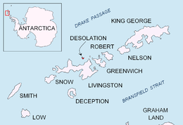

Burel Hill (Bulgarian: хълм Бурел, ‘Halm Burel’ \'h&lm 'bu-rel\) is the ice-free hill rising to 152 m in the northwest part of Desolation Island off Livingston Island in the South Shetland Islands, Antarctica. Surmounting Kozma Cove to the east and Hero Bay to the south and southwest.
The hill is named after the Burel region in Western Bulgaria.
Location
Burel Hill is located at 62°27′12.6″S 60°21′35″W / 62.453500°S 60.35972°WCoordinates: 62°27′12.6″S 60°21′35″W / 62.453500°S 60.35972°W, which is 2.1 km north-northwest of Iratais Point and 1.2 km south-southeast of Cape Danger. British mapping in 1968, and Bulgarian in 2005 and 2009.
Maps
- L.L. Ivanov et al. Antarctica: Livingston Island and Greenwich Island, South Shetland Islands. Scale 1:100000 topographic map. Sofia: Antarctic Place-names Commission of Bulgaria, 2005.
- L.L. Ivanov. Antarctica: Livingston Island and Greenwich, Robert, Snow and Smith Islands. Scale 1:120000 topographic map. Troyan: Manfred Wörner Foundation, 2009. ISBN 978-954-92032-6-4
References
- Bulgarian Antarctic Gazetteer. Antarctic Place-names Commission. (details in Bulgarian, basic data in English)
- SCAR Composite Gazetteer of Antarctica.
This article includes information from the Antarctic Place-names Commission of Bulgaria which is used with permission.