CHYDARU

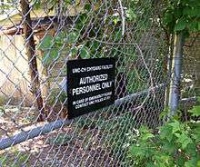
CHYDARU, unabbreviated name Chapel Hill Youth Development and Research Unit, is an experimental youth prison operated by the Institute of Government at the University of North Carolina at Chapel Hill and the North Carolina prison system.[1] Built in 1945, it opened as a prison for youth under the age of 18 on May 1, 1964.[2][3] The project was as an advancement in prison structure.[1] It closed later in 1965 due to budget shortages.[3] Sometime during the 1970s it housed the Bureau of School Services, which was operated by UNC.[4] Later in 1975, it was repurposed to store radioactive waste. It is inspected annually by the government to monitor the waste.[5]
Buildings in CHYDARU
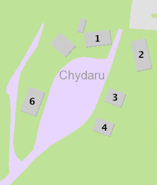
CHYDARU has 7 buildings located within its fence that are officially mapped and documented. There are 10 shelters included ones that have not been documented officially. Supposedly another building was destructed in 1985, but there is little evidence that it actually existed other than a crude map from 1977.[6][7]

Annex #1
Known also as "Shed at Chydaru", the shed it mostly open to the air except for one room with a desk and a one way mirror looking inwards. There is no official documentation on its purpose.[8][2]
Annex #2
Annex #2 is also known as the "Radiation Annex", it was built in 1935 and listed as a shed or trailer officially. A worn sign on the front of the building mentions the Department of Environment. A newer sign below the older sign says OCCUPATIONAL SAFETY AND HEALTH EDUCATIONAL RESOURCE CENTER ANNEX.[9][2]
Annex #3 and #4
UNC named the buildings "Extension Annex A" and "Extension Annex B", respectively. It was constructed in 1945, as many other building were. Both buildings have a bathroom built for several people and room for beds.[2] This leads many to believe that the prisoners were housed in each building. There is little difference between the two and they are located next to each other.[10][11]
Annex #6
Annex #6 is a two story building with a basement and ground floor. Built in 1945, there is no documentation for what it was ever used for.[12]
Aviary

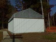
In 2006, an aviary was constructed along with an adjacent trailer in front of Annex #6. There is evidence that it was inhabited up to 2013. The UNC Satellite Facility Disaster Plan mentions that the aviary is near open water and not very high elevation, making it more likely for a natural disaster to effect it.[13][14]
References
- 1 2 "Popular government [serial]". archive.org. Retrieved 2016-11-27.
- 1 2 3 4 "CHYDARU Prison Camp". Retrieved 5 October 2016.
- 1 2 Keve, Paul W. (1967). Imaginative Programming in Probation & Parole. Minneapolis: University of Minnesota.
- ↑ "Full text of "University of North Carolina extension bulletin [serial]"". archive.org. Retrieved 2016-02-03.
- ↑ Briggs, Dennie (2000). "IN PRISON: Transitional Therapeutic Communities" (PDF). Planned Environment Therapy Trust Archive and Study Centre. Retrieved February 2, 2016.
- ↑ "Chydaru #5 Caretakers Cottage (446); Status - INACTIVE". UNC Plan Room. The University of North Carolina at Chapel Hill.
- ↑ "Record of the University of North Carolina at Chapel Hill, May 1977, Page 59 | Document Viewer". Mocavo. Retrieved 2016-02-03.
- ↑ "Shed at Chydaru #1". UNC Plan Room. University of North Carolina. Retrieved February 3, 2016.
- ↑ Radiation Annex - Chydaru #2 (255); Status - IN USE
- ↑ "Extension Annex A - Chydaru #3". UNC Plan Room. University of North Carolina. Retrieved 2 February 2016.
- ↑ "Extension Annex B - Chydaru #4". UNC Plan Room. University of North Carolina. Retrieved 2 February 2016.
- ↑ "Extension Annex - Chydaru #6". UNC Plan Room. University of North Carolina. Retrieved 3 February 2016.
- ↑ "UNC Satellite Facility Disaster Plan" (PDF). University of North Carolina. September 2013. Retrieved 3 February 2016.
- ↑ "UNC Plan Room: Facility Info". planroom.unc.edu. Retrieved 2016-02-04.
External links
- "Extension Annex A-Chydaru #3". GBIG. Retrieved 2 February 2016.
- Horace William Airport Study Outlying Parcel Land use study, Appendix B Environmental concerns Study, 1995 p. 13
- IN PRISON - Planned Environment Therapy Trust, D Briggs - 2000 fn17, p18 {PDF}
Coordinates: 35°53′37″N 79°00′58″W / 35.893637°N 79.0160624°W