Cahuish
For the mountain in the Lima Region, Peru, see Qawi.
| Cahuish | |
|---|---|
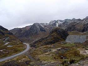 The southern slope of Cahuish(on the left) at the road above Qiruqucha | |
| Highest point | |
| Elevation | 4,900 m (16,100 ft) |
| Coordinates | 9°40′47″S 77°14′58″W / 9.67972°S 77.24944°WCoordinates: 9°40′47″S 77°14′58″W / 9.67972°S 77.24944°W |
| Geography | |
  Cahuish Location in Peru | |
| Location | Ancash, Peru |
| Parent range | Cordillera Blanca |
Cahuish[1][2] (possibly from Quechua qawi put into the sun)[3] is a mountain in the Cordillera Blanca in the Andes of Peru, about 4,900 metres (16,076 ft) high.[2] It is situated in the Ancash Region, Huari Province, Chavin de Huantar District, and in the Recuay Province, Ticapampa District. Cahuish lies southwest of the mountain and the archaeological site of Waraqayuq[4] and southeast of Yanamarey.[1][2]
References
- 1 2 Alpenvereinskarte 0/3b. Cordillera Blanca Süd (Peru). 1:100 000. Oesterreichischer Alpenverein. 2005. ISBN 3-937530-05-3.
- 1 2 3 Peru 1:100 000, Recuay (20-i). IGN (Instituto Geográfico Nacional - Perú).
- ↑ Teofilo Laime Ajacopa, Diccionario Bilingüe Iskay simipi yuyayk'ancha, La Paz, 2007 (Quechua-Spanish dictionary)
- ↑ Instituto Nacional de Cultura, Centro Nacional de Información Cultural, Contribución para un primer inventario general de sitios arqueológicos del Perú, Lima 2001
This article is issued from Wikipedia - version of the 6/19/2016. The text is available under the Creative Commons Attribution/Share Alike but additional terms may apply for the media files.