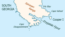
Cape Disappointment (South Georgia)

Southeast extremity of South Georgia
with Cape Disappointment
with Cape Disappointment
Pendleton's 1802 map showing Cape Disappointment
Cape Disappointment (54°53′S 36°7′W / 54.883°S 36.117°WCoordinates: 54°53′S 36°7′W / 54.883°S 36.117°W) is a headland which forms the southern extremity of South Georgia. It was first charted and so named in 1775 by a British expedition under James Cook, who upon reaching this position was greatly disappointed in realizing that South Georgia was an island rather than a continent.
References
-
 This article incorporates public domain material from the United States Geological Survey document "Disappointment, Cape" (content from the Geographic Names Information System).
This article is issued from Wikipedia - version of the 3/16/2013. The text is available under the Creative Commons Attribution/Share Alike but additional terms may apply for the media files.