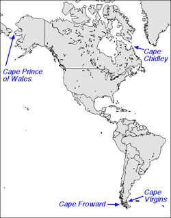
Cape Virgenes

Capes in the Americas
Cape Virgenes (Cabo Virgenes, Cape Virgins) is the southeastern tip of continental Argentina. Ferdinand Magellan reached it on 21 October 1520 and discovered a strait, now called the Strait of Magellan. As 21 October was the feast day of Saint Ursula and the Eleven Thousand Virgins, he named the cape in their honor.[1]
The Cape is located in Santa Cruz Province, Patagonia, Argentina. The Cape Virgenes Argentine Lighthouse has been operating since 1904. In 1884, gold was found there sparking the Tierra del Fuego Gold Rush.[2] Recently, rises in the number of southern right whales visiting the area have been confirmed.[3][4]
Climate
| Climate data for Cape Virgenes | |||||||||||||
|---|---|---|---|---|---|---|---|---|---|---|---|---|---|
| Month | Jan | Feb | Mar | Apr | May | Jun | Jul | Aug | Sep | Oct | Nov | Dec | Year |
| Daily mean °C (°F) | 10.2 (50.4) |
10.4 (50.7) |
9.1 (48.4) |
6.4 (43.5) |
4.1 (39.4) |
2.5 (36.5) |
2.2 (36) |
2.7 (36.9) |
3.8 (38.8) |
6.1 (43) |
8.0 (46.4) |
9.5 (49.1) |
6.3 (43.3) |
| Average precipitation mm (inches) | 43 (1.69) |
17 (0.67) |
22 (0.87) |
14 (0.55) |
22 (0.87) |
14 (0.55) |
24 (0.94) |
20 (0.79) |
12 (0.47) |
8 (0.31) |
29 (1.14) |
24 (0.94) |
249 (9.8) |
| Average relative humidity (%) | 76 | 73 | 77 | 81 | 84 | 87 | 86 | 84 | 79 | 73 | 73 | 73 | 79 |
| Source: Secretaria de Mineria,[5] | |||||||||||||
Gallery
- Magellanic penguins by their burrow in Cape Virgenes
 Sunset on Cape Virgenes
References
- ↑ Morison, Samuel (1974). The European Discovery of America: The Southern Voyages, 1492-1616. New York: Oxford University Press.
- ↑ Martinic Beros, Mateo. Crónica de las Tierras del Canal Beagle. 1973. Editorial Francisco de Aguirre S.A. Pp. 55-65
- ↑ The Fundación Cethus. 2014. Realizamos nuestra 5° campaña en Cabo Vírgenes, Santa Cruz. Retrieved on December 16. 2014
- ↑ The Fundación Cethus. 2011. Cuarta campaña para el estudio de la Ballena franca austral en Cabo Vírgenes. Retrieved on December 16. 2014
- ↑ "Provincia de Santa Cruz - Clima Y Meteorologia: Datos Meteorologicos Y Pluviometicos" (in Spanish). Secretaria de Mineria de la Nacion (Argentina). Archived from the original on January 19, 2015. Retrieved August 19, 2015.
Coordinates: 52°20′S 68°21′W / 52.333°S 68.350°W
This article is issued from Wikipedia - version of the 9/4/2016. The text is available under the Creative Commons Attribution/Share Alike but additional terms may apply for the media files.