Justiniana Prima
| Justiniana Prima | |
|---|---|
|
Native name Serbian: Царичин град | |
|
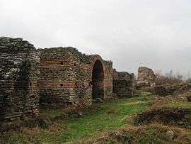
Remnants of the city | |
| Location | Prekopčelica, Lebane |
| Founded | 535 AD |
| Built for | Archbishopric, Imperial estate |
| Demolished | 615 |
| Governing body | Republic of Serbia |
| Official name: Caričin Grad | |
| Type |
Cultural Heritage of Serbia: Archaeological Sites of Exceptional Importance |
| Designated | 1979 |
Justiniana Prima (Serbian: Царичин град) was a Byzantine city that existed from 535 to 615, and currently an archaeological site, near today's Lebane, Leskovac district in southern Serbia. It was founded by Emperor Justinian I and served as the seat of an Archbishopric that had jurisdiction of the Central Balkans.
In 1979, Justiniana Prima was added to the Archaeological Sites of Exceptional Importance-list, protected by Republic of Serbia.
Background
The establishment of the Archbishopric is mentioned in Justinian's own Novel XI from 535, when he promotes the Metropolitan to an Archbishop, independent from the Archbishop of Thessalonica. The establishment is seen as part of the feud between Justinian and the Archbishop of Eastern Illyricum, who was a papal vicar.[1]
History

The city was founded by Emperor Justinian I. It existed from the 530s to 615 and was designed as a splendid bishop's seat. The city was a completely new foundation in honour of the nearby village of Tauresium (identified with today's village of Taor in the Republic of Macedonia, near Skopje), the birthplace of Justinian. Serb scholars also identify it as the site of Bederiana, birthplace of Justinian's uncle and mentor Justin I. The city planning combined classical and Christian elements: thermae, a forum, and streets with colonnades. Typical Mediterranean features went along with numerous churches.
Justinian himself ordered the foundation of the city by law in 535, establishing the Archbishopric of Justiniana Prima, making it at the same time the capital of the prefecture of Illyricum instead of Thessaloniki (although this is disputed among historians). It also was chosen as the seat of the Dacian diocese.
Thessaloniki, however, did not actually lose much of its administrative functions during the short lifetime of Justiniana Prima. Still, the new foundation was not without importance and Justinian made sure that this city, which was one of his favourite projects, received all the necessary support. In 545 Justinian issued another law underlining the episcopal rights and status of Justiniana Prima, which is also confirmed by letters that were exchanged between Justinian and Pope Gregory I at the end of the 6th century.
In 615 the city was destroyed by invading Avars coming from north of the Danube.
"He therefore built a wall of small compass about this place in the form of a square, placing a tower at each corner, and caused it to be called, as it actually is, Tetrapyrgia. And close by this place he built a very notable city which he named Justiniana Prima, thus paying a debt of gratitude to the home that fostered him. In that place also he constructed an aqueduct and so caused the city to be abundantly supplied with ever-running water. And many other enterprises were carried out by the founder of this city - works of great size and worthy of especial note. For to enumerate the churches is not easy, and it is impossible to tell in words of the lodgings for magistrates, the great stoas, the fine marketplaces, the fountains, the streets, the baths, the shops. In brief, the city is both great and populous and blessed in every way." (Procopius' description of Justiniana Prima in The Buildings)
Two fibulae[2] and Slavic pottery made 550–600 show that a considerable part of the inhabitants of Justiniana Prima were Slavs before the Avar incursion.[3]
Archaeological site
There have been archaeological excavations for nearly 150 years with the participation of French researchers.
See also
References
- http://web.rgzm.de/fileadmin/gruppen/rgzm/IvanisevicCaricinGrad.pdf
- William Bowden (2003), "Theory and practice in late antique archaeology", pp. 207–220, BRILL, ISBN 978-90-04-12567-4
- Florin Curta (2001), "The making of the slavs: history and archaeology of the Lower Danube Region, ca. 500-700", pp. 77, 121-125, 130-131, 144-145, 152-153, 172,
- J. A. S. Evans (2000), "The age of Justinian: the circumstances of imperial power", pp. 96–97, 189, 227-228,
- The challenge of our past: studies in Orthodox Canon law and Church history
- Đorđe Janković, The Slavs in the 6th century North Illyricum
External links
| Wikimedia Commons has media related to Justiniana Prima. |
- Bavant, Bernard. "Caričin Grad". Caričin Grad: istraživanja u 1999. godini. Arheološki Institut, Beograd. Retrieved 6 October 2010.
- 3-D animation Justiniana Prima
Coordinates: 42°57′11.69″N 21°40′11.90″E / 42.9532472°N 21.6699722°E

