Carmichael, Saskatchewan
For other uses, see Carmichael.
| Carmichael, Saskatchewan | |
|---|---|
| Village | |
  Carmichael, Saskatchewan  Carmichael, Saskatchewan | |
| Coordinates: 50°03′29″N 108°47′28″W / 50.058°N 108.791°W | |
| Country | Canada |
| Province | Saskatchewan |
| Region | Saskatchewan |
| Census division | 4 |
| Rural Municipality | Carmichael |
| Government | |
| • Governing body | Carmichael Village Council |
| • Mayor | Miles C. Wells |
| • Administrator | Collette Jones |
| Area | |
| • Total | 0.67 km2 (0.26 sq mi) |
| Population (2006) | |
| • Total | 10 |
| • Density | 15.0/km2 (39/sq mi) |
| Time zone | CST |
| Postal code | S0N 1A0 |
| Area code(s) | 306 |
| Highways | Highway 1 |
| Railways | Canadian Pacific Railway |
| [1][2][3][4] | |
Carmichael is a village in Carmichael Rural Municipality No. 109, Saskatchewan, Canada. The population was 10 at the 2006 Census. The village is located 1 km (1 mi) south of Highway 1 approximately 158 km (98 mi) east of Medicine Hat, Alberta.
Demographics
| Canada census – Carmichael, Saskatchewan community profile | |||
|---|---|---|---|
| 2011 | 2006 | 2001 | |
| Population: | 30 (200% from 2006) | 10 (-50.0% from 2001) | 20 (-13.0% from 1996) |
| Land area: | 0.67 km2 (0.26 sq mi) | 15.0 km2 (5.8 sq mi) | 0.67 km2 (0.26 sq mi) |
| Population density: | 45.1/km2 (117/sq mi) | 0.67/km2 (1.7/sq mi) | 30.1/km2 (78/sq mi) |
| Median age: | N/A (M: N/A, F: N/A) | N/A (M: N/A, F: N/A) | N/A (M: N/A, F: N/A) |
| Total private dwellings: | 16 | 9 | 13 |
| Median household income: | $N/A | $N/A | $NA |
| References: 2011[5] 2006[6] 2001[7] | |||
Attractions
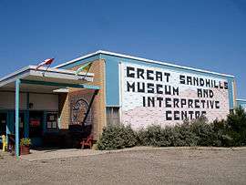
Great Sandhills Museum in Sceptre
- Big Muddy Badlands, a series of badlands in southern Saskatchewan and northern Montana along Big Muddy Creek. They are found in the Big Muddy Valley, a cleft of erosion and sandstone along Big Muddy Creek. The valley is 55 kilometres (34 mi) long, 3.2 kilometres (2.0 mi) wide and 160 metres (520 ft) deep.[8] The valley was formed when it was part of an ancient glacial meltwater channel that carried great quantities of water southeastward during the last ice age.[9]
- Cypress Hills Interprovincial Park, an interprovincial park straddling the southern Alberta-Saskatchewan border, located north-west of Robsart. It is Canada's first and only interprovincial park.
- Cypress Hills Vineyard & Winery, open by appointment only from Christmas until May 14.[10]
- Fort Walsh, is part of the Cypress Hills Interprovincial Park. As a National Historic Site of Canada the area possesses National Historical Significance. It was established as a North-West Mounted Police (NWMP) fort after and at the location of the Cypress Hills Massacre.
- Grasslands National Park, represents the Prairie Grasslands natural region, protecting one of the nation's few remaining areas of undisturbed dry mixed-grass/shortgrass prairie grassland. The park is located in the WWF-defined Northern short grasslands ecoregion, which spans across much of Southern Saskatchewan, Southern Alberta, and the northern Great Plains states in the United States. The unique landscape and harsh, semi-arid climate provide niches for several specially adapted plants and animals. The park and surrounding area house the country's only black-tailed prairie dog colonies. Other rare and endangered fauna that can be found in the park include the pronghorn, sage grouse, burrowing owl, ferruginous hawk, prairie rattlesnake, black-footed ferret and eastern short-horned lizard. Flora includes blue grama grass, needlegrass, Plains Cottonwood and silver sagebrush.
- The Great Sandhills, is a sand dune rising 50 feet above the ground and covering 1,900 square kilometers. Native prairie grass helps keep the sand together. The sand dunes are fringed by small groves of aspen, birch, and willow trees, and by rose bushes, chokecherry and sagebrush. Subjected to strong winds, the dunes are always moving, creating an ever-changing landscape for photographers.[11]
- Robsart Art Works, opens July 1 to August 28, 2010 from 1 to 4 p.m. and by appointment and features Saskatchewan artists featuring photographers of old buildings and towns throughout Saskatchewan.[12]
- T.rex Discovery Centre, a world class facility to house the fossil record of the Eastend area started many years before the discovery of "Scotty" the T.Rex in 1994.[13]
See also
References
- ↑ National Archives, Archivia Net, Post Offices and Postmasters, archived from the original on 2006-10-06
- ↑ Government of Saskatchewan, MRD Home, Municipal Directory System, archived from the original (– Scholar search) on November 21, 2008
- ↑ Canadian Textiles Institute. (2005), CTI Determine your provincial constituency, archived from the original on 2007-09-11
- ↑ Commissioner of Canada Elections, Chief Electoral Officer of Canada (2005), Elections Canada On-line, archived from the original on 2007-04-21
- ↑ "2011 Community Profiles". Canada 2011 Census. Statistics Canada. July 5, 2013. Retrieved 2012-10-30.
- ↑ "2006 Community Profiles". Canada 2006 Census. Statistics Canada. March 30, 2011. Retrieved 2009-02-24.
- ↑ "2001 Community Profiles". Canada 2001 Census. Statistics Canada. February 17, 2012.
- ↑ Yanko, Dave. "The Badlands". Virtual Saskatchewan. Retrieved 2010-05-11.
- ↑ Harel, Claude-Jean (2006). "Big Muddy Valley". Encyclopedia of Saskatchewan. Great Plains Research Center. Retrieved 2010-05-11.
- ↑ Cypress Hills Vineyard & Winery
- ↑ Great Sandhills
- ↑ Robsart Art Works
- ↑ T.rex Discovery Centre
External links
 |
Fox Valley | Hazlet | Webb | |
| Tompkins |  |
Gull Lake | ||
| ||||
 | ||||
| Eastend | Dollard | Shaunavon |


 Subdivisions of Saskatchewan Subdivisions of Saskatchewan | |
|---|---|
| Subdivisions | |
| Communities | |
| Cities | |
| Topics |
|
| |


Coordinates: 50°03′29″N 108°47′28″W / 50.058°N 108.791°W
This article is issued from Wikipedia - version of the 11/15/2016. The text is available under the Creative Commons Attribution/Share Alike but additional terms may apply for the media files.