Carutapera
| Carutapera | |
|---|---|
| Municipality | |
| The Municipality of Carutapera | |
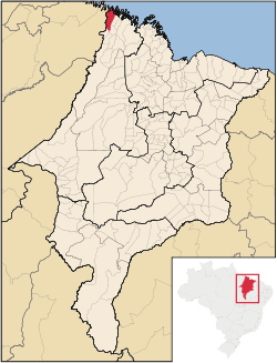 Location of Carutapera | |
| Coordinates: 01°11′42″S 46°01′12″W / 1.19500°S 46.02000°WCoordinates: 01°11′42″S 46°01′12″W / 1.19500°S 46.02000°W | |
| Country |
 Brazil Brazil |
| Region | Northeast |
| State |
 Maranhão Maranhão |
| Founded | June 3, 1935 |
| Government | |
| • Mayor | Vitoria da Gloria de Oliveira Borges Alves |
| Area | |
| • Total | 1,255.555 km2 (484.772 sq mi) |
| Population (2008) | |
| • Total | 20,905 |
| • Density | 16.4/km2 (42/sq mi) |
| [1] | |
| Time zone | UTC-3 (UTC-3) |
| HDI (2000) | 0.571 – medium[2] |
| Website | www.carutapera.ma.gov.br |
Carutapera is the northernmost city in the Brazilian state of Maranhão.
References
- ↑ IBGE 2008 statistics
- ↑ "Archived copy". Archived from the original on 2009-10-03. Retrieved 2009-12-17. - UNDP

This article is issued from Wikipedia - version of the 11/16/2016. The text is available under the Creative Commons Attribution/Share Alike but additional terms may apply for the media files.