Castlecrag Mountain
| Castlecrag Mountain | |
|---|---|
 | |
| Highest point | |
| Elevation | 1,765 m (5,791 ft) [1] |
| Prominence | 123 m (404 ft) [1] |
| Coordinates | 49°39′45″N 125°23′13″W / 49.66250°N 125.38694°WCoordinates: 49°39′45″N 125°23′13″W / 49.66250°N 125.38694°W [2] |
| Geography | |
 Castlecrag Mountain Location of Castlecrag Mountain in SE B.C. | |
| Location | Vancouver Island, British Columbia, Canada |
| Parent range | Vancouver Island Ranges |
| Topo map | NTS 92F/11 |
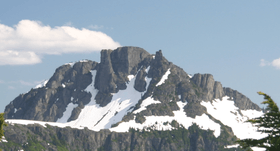
Castlecrag Mountain is a mountain located on Vancouver Island, British Columbia. Castlecrag Mountain is located South of Moat Lake, 1.6 km West of Mount Frink along the same ridge line.
Castlecrag Mountain is often climbed as part of the Castlecrag - Mt. Frink loop. This route starts at Circlet Lake, accessed from Paradise Meadows and the Mount Washington Alpine Resort.
History
The name Castlecrag Mountain comes from the appearance of the North aspect. The Geographic Board of the BC Geographic Names Office deemed Castle Crag too obscure, instead adopting Castlecrag Mountain in 1948.[2]
See also
References
- 1 2 "Castlecrag Mountain". Bivouac.com. Retrieved 2009-06-17.
- 1 2 "Castlecrag Mountain". BC Geographical Names. Retrieved 2009-06-17.
External links
- "Castlecrag Mountain". Bivouac.com.
This article is issued from Wikipedia - version of the 12/6/2015. The text is available under the Creative Commons Attribution/Share Alike but additional terms may apply for the media files.