Cheruvathur
| Cheruvathur ചെറുവത്തൂർ | |
|---|---|
| Town | |
|
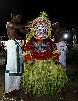
Pottam Theyyam at Cheruvathur | |
 Cheruvathur  Cheruvathur Location in Kerala, India | |
| Coordinates: 12°19′00″N 75°04′59″E / 12.3167°N 75.083°ECoordinates: 12°19′00″N 75°04′59″E / 12.3167°N 75.083°E | |
| Country |
|
| State | Kerala |
| District | Kasaragod |
| Area | |
| • Total | 18.37 km2 (7.09 sq mi) |
| Languages | |
| • Official | Malayalam, English |
| Time zone | IST (UTC+5:30) |
| PIN | 671313 |
Cheruvathur is a growing town in the Kasaragod district, state of Kerala. It is located 58 km from the district headquarters at Kasaragod Town.
Etymology
The name comes from "cheriya pathu ooru" (ten small places). In 2010, the authorities decided to rename the town Kuttamath Nagar after the poet Kuttamath.[1]
Tourism
Cheruvathur has a viewpoint on the national highway to Calicut. The view from this location includes Cheruvathur railway station amid sprawling paddy fields and village houses. Even though hundreds of people stop their vehicles at this location, no basic facilities are provided here. Railings and paved footpaths are essential. One private restaurant is the only facility available right now to the tourists.
Transportation
Local roads have access to NH.66 which connects to Mangalore in the north and Calicut in the south. The nearest railway station is Cheruvathur on Mangalore-Palakkad line. There are airports at Mangalore and Calicut.
See also
.jpg) Vellur mosque
Vellur mosque
References
- ↑ "Work on fishing harbour begins". Hindu.com. 2010-08-14. Retrieved 2012-06-30.
External links
| Wikimedia Commons has media related to Cheruvathur. |
