Chintsa
| Chintsa | |
|---|---|
|
Chintsa | |
  Chintsa  Chintsa  Chintsa
| |
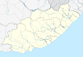
| Coordinates: 32°49′S 28°6′E / 32.817°S 28.100°ECoordinates: 32°49′S 28°6′E / 32.817°S 28.100°E | |
| Country | South Africa |
| Province | Eastern Cape |
| District | Amathole |
| Municipality | Great Kei |
| Area[1] | |
| • Total | 4.10 km2 (1.58 sq mi) |
| Population (2011)[1] | |
| • Total | 1,740 |
| • Density | 420/km2 (1,100/sq mi) |
| Racial makeup (2011)[1] | |
| • Black African | 83.8% |
| • Coloured | 0.6% |
| • Indian/Asian | 0.2% |
| • White | 14.5% |
| • Other | 0.9% |
| First languages (2011)[1] | |
| • Xhosa | 81.4% |
| • English | 12.1% |
| • Afrikaans | 4.3% |
| • Other | 2.3% |
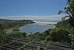
Chintsa (formerly Cintsa)[2] is a village in the Wild Coast region of the Eastern Cape province, South Africa. It is situated 38 km north-east from East London,[3] at the mouth of the Cintsa river.
There are two resort areas catering to tourists interested in sea fishing to the east and west of the river.[4]
The village is in Xhosa country. It has a laid-back atmosphere with low-cost accommodation and unspoilt white sand beaches in Chintsa East, backed by forested dunes, lagoons and rivers.[5][6]
References
- 1 2 3 4 "Main Place Chintsa". Census 2011.
- ↑ Jenkins, Elwyn (2007), Falling into place: the story of modern South African place names, David Philip Publishers, p. 75
- ↑ "Cintsa South Africa". drakensberg-tourism.com. Retrieved 2009-09-10.
- ↑ Ivor Whibley (2003). The South African Fisherman. Struik. p. 122. ISBN 1-86872-802-1.
- ↑ Mary Fitzpatrick; Kate Armstrong (2006). South Africa, Lesotho & Swaziland. Lonely Planet. ISBN 1-74059-970-5.
- ↑ Tony Pinchuck; Barbara McCrea; Donald Reid (2002). Rough guide to South Africa, Lesotho & Swaziland. Rough Guides. p. 421. ISBN 1-85828-853-3.
 |
Wikivoyage has a travel guide for Cintsa. |
Municipalities and communities of Amathole District Municipality, Eastern Cape | ||
|---|---|---|
District seat: East London | ||
| Amahlathi | .svg.png) | |
| Great Kei | ||
| Mbhashe | ||
| Mnquma | ||
| Ngqushwa | ||
| Raymond Mhlaba | ||
This article is issued from Wikipedia - version of the 5/28/2016. The text is available under the Creative Commons Attribution/Share Alike but additional terms may apply for the media files.