Chirpan Peak
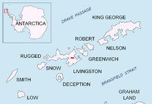
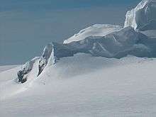

Chirpan Peak (Vrah Chirpan \'vr&h chir-'pan\) is an ice covered 535 m peak forming the western extremity of Bowles Ridge on Livingston Island in the South Shetland Islands, Antarctica overlooking Perunika Glacier to the west and south. The peak is named after the town of Chirpan in southern Bulgaria.
Location
The peak is located at 62°36′53.5″S 60°13′34″W / 62.614861°S 60.22611°WCoordinates: 62°36′53.5″S 60°13′34″W / 62.614861°S 60.22611°W which is 1.23 km west of the summit Mount Bowles, 1.01 km south-southwest of Hemus Peak, 2.85 km east-northeast of Rezen Knoll and 1.12 km northwest of Svoge Knoll.
Bulgarian mapping in 2005 and 2009 from the Tangra 2004/05 topographic survey.
Maps
- L.L. Ivanov et al. Antarctica: Livingston Island and Greenwich Island, South Shetland Islands. Scale 1:100000 topographic map. Sofia: Antarctic Place-names Commission of Bulgaria, 2005.
- L.L. Ivanov. Antarctica: Livingston Island and Greenwich, Robert, Snow and Smith Islands. Scale 1:120000 topographic map. Troyan: Manfred Wörner Foundation, 2009. ISBN 978-954-92032-6-4
References
This article includes information from the Antarctic Place-names Commission of Bulgaria which is used with permission.