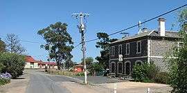
Clarkefield, Victoria
| Clarkefield Victoria | |||||||||||||
|---|---|---|---|---|---|---|---|---|---|---|---|---|---|
 Station Street | |||||||||||||
 Clarkefield | |||||||||||||
| Coordinates | 37°29′S 144°45′E / 37.483°S 144.750°ECoordinates: 37°29′S 144°45′E / 37.483°S 144.750°E | ||||||||||||
| Population | 433 (2011 census)[1] | ||||||||||||
| Postcode(s) | 3430[2] | ||||||||||||
| Elevation | 308 m (1,010 ft) | ||||||||||||
| Location | |||||||||||||
| LGA(s) | |||||||||||||
| County | Bourke | ||||||||||||
| State electorate(s) | |||||||||||||
| Federal Division(s) | McEwen | ||||||||||||
| |||||||||||||
Clarkefield (/ˈklɑːrkfiːld/, locally [ˈklaːkfiːld]) is a town in Victoria, Australia, 46 kilometres (29 mi) northwest of Melbourne's central business district. Its local government area is the City of Hume[2] and Shire of Macedon Ranges. At the 2011 Census, Clarkefield had a population of 433.
The Post Office opened on 1 January 1862 and was known as Lancefield Road until 1881, Lancefield Junction until 1926 and closed in 1982.[3]
Jacksons Creek, a tributary of the Maribyrnong river at Clarkefield
See also
- Shire of Bulla - the former local government area of which Clarkefield was a part
- Shire of Romsey - the former local government area of which Clarkefield was a part
- Clarkefield railway station, Victoria
References
- ↑ Australian Bureau of Statistics (31 October 2012). "Clarkefield (State Suburb)". 2011 Census QuickStats. Retrieved 2012-06-22.
- 1 2 "Postcodes within Hume City Council". Hume City Council. Retrieved 2008-01-13.
- ↑ Premier Postal History. "Post Office List". Retrieved 2008-04-11.
This article is issued from Wikipedia - version of the 12/24/2015. The text is available under the Creative Commons Attribution/Share Alike but additional terms may apply for the media files.