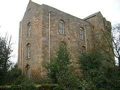
Cocklepark Tower
Coordinates: 55°12′47″N 1°41′02″W / 55.213°N 1.684°W
| Cocklepark Tower | |
|---|---|
|
Cocklepark Tower | |
 Cocklepark Tower | |
| OS grid reference | NZ202910 |
| |
Cocklepark Tower is in the hamlet of Cockle Park, Northumberland, England some 4 miles (6 km) to the north of Morpeth.
This was a three-storied tower-house which was built in the 15th century as a hunting lodge.[1] It was later extended by the addition of a domestic building. It was being used as a student's hospital until the mid–1970s at which time major structural problems became apparent.[1] The University of Newcastle is planning to develop this building as part of the overall development of Cockle Park farm into the Centre for Renewable Energy from Land (CREEL).[2]
Cockle Park Tower is a Grade 1 listed building.[3]
References
- 1 2 "Cockle Park Tower". www.gatehouse-gazetteer.info. Retrieved 2 March 2016.
- ↑ Bilsborrow, Paul. "Centre for Renewable Energy from Land (CREEL)" (pdf). Newcastle University. Retrieved 2 March 2016.
- ↑ "Cockle Park Tower: List Entry 1042088". www.historicengland.org.uk. Historic England. Retrieved 2 March 2016.
- Fry, Plantagenet Somerset, The David & Charles Book of Castles, David & Charles, 1980. ISBN 0-7153-7976-3
This article is issued from Wikipedia - version of the 3/2/2016. The text is available under the Creative Commons Attribution/Share Alike but additional terms may apply for the media files.
