Cop Mere
| Site of Special Scientific Interest | |
 | |
 Location within Staffordshire | |
| Area of Search | Staffordshire |
|---|---|
| Grid reference | SJ802297 |
| Coordinates | 52°51′54″N 2°17′41″W / 52.86487°N 2.29481°WCoordinates: 52°51′54″N 2°17′41″W / 52.86487°N 2.29481°W |
| Interest | Biological |
| Area | 93.4 acres (0.3780 km2; 0.1459 sq mi) |
| Notification | 1968 |
| Natural England website | |
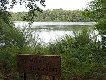
Cop Mere is one of the largest natural bodies of water in Staffordshire, England. It has been designated a SSSI as an oligotrophic mire rich in Sphagnum moss,[1] and other plant and animal life are present in sufficient numbers and rarities for it to have been designated as a protected area since 1968.
Cop Mere was created as a hollow in the Keuper marl of North Staffordshire/South Cheshire approx 200 million years ago,[2] roughly as a result of the retreat of the last ice age. It differs from other ponds and meres in the region because it sits on the route of the River Sow, the flow of which encourages the growth of algae necessary for the growth of freshwater mosses. The River Sow has been dammed upstream at Jackson's coppice from around AD 1250,[3] which altered the flow of water and created a unique albeit man-made environment that encourages birdlife and fishlife. There is evidence that fishing in Cop Mere dates back at least to the reign of Henry VIII.[4]
The SSSI also includes a number of plants currently rare in Staffordshire, specifically herb paris (Paris quadrifolia) and the thin-spiked wood sedge, Carex strigosa.[1] Birds commonly found on the mere include the reed warbler and sedge warbler, the great crested grebe and the little grebe, the sparrowhawk, and various woodpeckers.
See also
References
- 1 2 "County: Stafforshire; Site Name: Cop Mere" (PDF). English-nature.org.uk. Retrieved 2012-09-15.
- ↑ Geoffrey Warrington (1970). "The stratigraphy and palaeontology of the 'Keuper' Series of the central Midlands of England". Quarterly Journal of the Geological Society. 126 (1–4): 183–223. doi:10.1144/gsjgs.126.1.0183.
- ↑ "Jackson's Coppice & Marsh". Staffordshire Wildlife Trust. Retrieved September 15, 2012.
- ↑ "Minor correspondence". The Gentleman's Magazine. 91: 386. 1829.