County of Robinson
This article is about the South Australian cadastral division. For the New South Welsh cadastral division, see Robinson County.
| Robinson South Australia | |||||||||||||
|---|---|---|---|---|---|---|---|---|---|---|---|---|---|
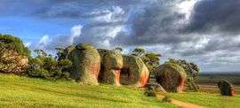 Murphy's Haystacks at Mortana in the Hundred of Rounsevell | |||||||||||||
 Robinson | |||||||||||||
| Coordinates | 32°53′S 134°42′E / 32.88°S 134.70°ECoordinates: 32°53′S 134°42′E / 32.88°S 134.70°E | ||||||||||||
| Established | 1883 | ||||||||||||
| Area | 6,926 km2 (2,674.1 sq mi) | ||||||||||||
| |||||||||||||
The County of Robinson is one of the 49 counties of South Australia. It was proclaimed in 1883 by Governor William Robinson who named it after himself.[1] It lies on the north west coast of Eyre Peninsula stretching from Streaky Bay inland to include the Gawler Ranges Conservation Park at the southern cusp of the Gawler Ranges.[1]
Hundreds
The County of Robinson is divided into the following 24 hundreds which cross over the Streaky Bay district and Wudinna district council areas:
- Hundred of Finlayson (Perlubie, Petina)
- Hundred of Tarlton (Chilpenunda)
- Hundred of Cungena (Cungena)
- Hundred of Kaldoonera (Kaldoonera)
- Hundred of Bockelberg (Bockelberg)
- Hundred of Scott (Eba Anchorage, Piednippie)
- Hundred of Murray (Piednippie, Chandada)
- Hundred of Chandada (Chandada)
- Hundred of Karcultaby (Poochera, Karcultaby)
- Hundred of Condada (Minnipa)
- Hundred of Ripon (Streaky Bay, Yanerbie)
- Hundred of Forrest (Streaky Bay, Yanerbie)
- Hundred of Campbell (Maryvale)
- Hundred of Inkster (Inkster)
- Hundred of Moorkitabie (Karcultaby)
- Hundred of Carina (Minnipa)
- Hundred of Wrenfordsley (Sceale Bay, Calca, Baird Bay)
- Hundred of Rounsevell (Mortana, Tyringa, Witera)
- Hundred of Witera (Colley, Mount Cooper)
- Hundred of Addison (Karcultaby)
- Hundred of Travers (Mount Damper)
- Hundred of Wright (Venus Bay, Port Kenny)
- Hundred of Downer (Talia)
- Hundred of Wallis (Mount Damper, Cocata)
A twenty fifth county subdivision, the Hundred of McBeath, was planned or possibly proclaimed between the hundreds of Wright, Addison, Travers, Wallis and Downer, but the name was never gazetted.[2]
References
- 1 2 "Search for 'County of Robinson, CNTY' (ID SA0059070)". Government of South Australia. Retrieved 22 July 2016.
Other Details: Area 2674 square miles. Sir William Clever Frances Robinson, KCMG, Governor of South Australia 19 Feb 1883 to 5 March 1889. Position 32:54S, 134:37E.
- ↑ "Search for 'Hundred of McBeath, HD' (ID SA0043718)". Government of South Australia. Retrieved 22 July 2016.
Land north of the Hundred of Downer. It is not known what status this name has at present, no indication can be found that the name was ever gazetted. No extent established.
This article is issued from Wikipedia - version of the 8/24/2016. The text is available under the Creative Commons Attribution/Share Alike but additional terms may apply for the media files.