Cyclone Ami
| Category 3 severe tropical cyclone (Aus scale) | |
|---|---|
| Category 3 (Saffir–Simpson scale) | |
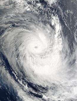
 Satellite image of Cyclone Ami on January 13 | |
| Formed | January 9, 2003 |
| Dissipated | January 15, 2003 |
| Highest winds |
10-minute sustained: 150 km/h (90 mph) 1-minute sustained: 205 km/h (125 mph) |
| Lowest pressure | 950 hPa (mbar); 28.05 inHg |
| Fatalities | 14 |
| Damage | $51.2 million (2003 USD) |
| Areas affected | Fiji, Tuvalu, Tonga |
| Part of the 2002–03 South Pacific cyclone season | |
Severe Tropical Cyclone Ami (RSMC Nadi designation: 05F, JTWC designation: 10P) was one of the worst cyclones to affect Fiji. The system was the third cyclone and the second severe tropical cyclone of the 2002–03 South Pacific cyclone season. Cyclone Ami developed from a low-pressure area east of Tuvalu on January 12. Originally, the storm moved slowly towards the southwest early in its existence. Influenced by an upper-level trough, Ami slowed down and began moving towards the south and then southeast. The cyclone attained severe tropical cyclone intensity on January 13. Ami made its first landfall at Vanua Levu, before subsequently making another landfall on Taveuni. Still intensifying, Ami reached peak intensity as an equivalent Category 3 cyclone on the Australian and Fiji cyclone scales on January 14. Accelerating to the southeast, the cyclone began to cross over cool sea surface temperatures and encountered wind shear. Ami transitioned into an extratropical cyclone the day after.
Cyclone Ami severely impacted areas of Fiji, primarily causing flooding. Numerous landslides and power outages resulted from the heavy rains. Damage was particularly severe in Labasa, Fiji, where floodwater inundated the entire city. Damage sustained to crops was also severe, especially the sugar cane, where production decreased by 15% due to Ami. In Tonga, damage was not as severe. However, two ships offshore were grounded due to the cyclone. Ami caused F$104.4 million (US$51.2 million)[nb 1] in damages and 17 deaths, primarily on Fiji. Following the deaths and damage, the name "Ami" was later retired.
Meteorological history

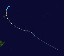
On January 9, 2003, the Fiji Meteorological Service's Regional Specialized Meteorological Centre in Nadi (RSMC Nadi) started to monitor a weak tropical depression, that had developed within a monsoon trough about 800 km (495 mi) to the northwest of Apia, Samoa.[1] Over the next two days as the system moved towards the southwest further development of the depression was inhibited by strong vertical windshear, before during January 11, the vertical windshear decreased and the system started to rapidly develop further.[1][2] As it developed further the United States Joint Typhoon Warning Center issued a tropical cyclone formation alert on the system, before they designated it as Tropical Cyclone 10P later that day as the 1-minute sustained windspeeds became equivalent to a tropical storm.[3] RSMC Nadi subsequently reported six hours later that the depression had developed into a category one tropical cyclone on the Australian tropical cyclone intensity scale, and named it as Ami, while it was located just to the east of the southern Tuvalu island of Niulakita.[1]
Tracking southwest, the storm was named Tropical Cyclone Ami at approximately 0000 UTC on January 12 under favorable upper-level diffluence facilitated by the nearby ridge of high pressure.[3][4] Influenced by an upper-level trough, Ami slowed in forward movement and turned on a more southerly course. With minimal wind shear and a good outflow pattern, Ami achieved severe tropical cyclone intensity at 0600 UTC on January 13.[5] A poorly defined eye feature became visible on satellite imagery, at which point the storm was situated around 160 mi (260 km) north-northeast of Labasa. The cyclone made landfall on Vanua Levu with a minimum barometric pressure of 960 mbar (28.4 inHg) before subsequently crossing the western tip of Taveuni. Broadly turning toward the southeast, Ami traversed the Lau Islands.[4] While located about 60 miles south of Lakeba – at 0600 UTC on January 14 – the storm reached its peak intensity with 10-minute maximum sustained winds of 90 mph (140 km/h) and a pressure of 950 mbar (28.0 inHg).[5][6] At the same time, the JTWC assessed the storm with 1-minute winds of 125 mph (201 km/h).[7]
Accelerating toward the southeast with forward speed reaching 40 mph (64 km/h), Ami began to gradually weaken due to resuming wind shear and increasingly cool waters. The cyclone interacted with a frontal boundary, and in doing so it transitioned to an extratropical cyclone. Ami lost all tropical characteristics by 1200 UTC on January 15, although its remnants continued eastward to a point well south of Rarotonga.[4][5] On January 14, RSMC Nadi issued their final advisory on Ami and passed the primary warning responsibility for Cyclone Ami to the Wellington Tropical Cyclone Warning Center (TCWC Wellington) as the system moved below 25 °S.[8]
Preparations and impact
Fiji

Prior to the storm, 30 evacuation shelters were opened.[9] On Lavau Island, residents took shelter in limestone caves to avoid the oncoming storm surge.[10]
After the storm, major damage was recorded to houses, crops, schools across Fiji. Heavy rainfall led to landslides and intensive flooding, and combined with storm surges to give rise to dangerous flash floods.[11] The maximum rainfall total was 311 mm (12.2 in), recorded at the coastal site of Vatuwiri on Taveuni Island.[12] Due to the rugged terrain of the island, the rains resulted in heavy flooding.[12] Power lines were cut off in Vanua Levu, Taveuni, and the Lau Islands, resulting in widespread power outage.[13] In Vanua Levu, damage to crops and bush material were reported.[14] The island was also damaged by strong tidal swells and storm surge.[15] Communications with the island were cut off at approximately 1700 UTC, preventing damage reports from being communicated for a period of time.[16] Labasa, Fiji was inundated under 1.2 m (3.9 ft) of water.[16] The city's morgue could not operate due to damage sustained by Ami. As a result, bodies found in the area had to be cremated.[17] An entire family was reported to have drowned after their house was inundated by rising floodwater.[18] Two children went missing an others were injured when a wooden church on Druadrua Island being used as a shelter collapsed.[9] However, the two children were later found alive in the debris.[18] St. Bede's College in Suva was severely damaged by Ami.[19]
Across much of the islands, agricultural damage was widespread. Primarily due to damages sustained on the Fiji Sugar Corporation sugar mill in Labasa, sugar cane production in 2003 dropped by 800,000 tonnes (882,000 short tons), equivalent to 15% less than forecast. Coconut plantations also sustained heavy damages.[4] In Lau Province and Lomaiviti Province, an estimated 158 houses were completely destroyed. In the two provinces, damages totaled to F$4.5 million (US$2.2 million). However, in Macuata, Cakaudrove, and Bua provinces, 2,287 houses were destroyed. In those three provinces, damages were estimated to be F$23.7 million (US$11.6 million).[4]
After Fiji cut water supplies, residents feared that the water would be contaminated with disease and other chemicals.[20] As a result of Ami, F$104.4 million (US$51.2 million) in damages resulted from the cyclone, and 14 people died.[21]
Tonga
In Tonga, no significant damage was reported, although minor power outages occurred on some islands.[22] Nuku'alofa reported maximum wind speeds of 75 km/h (45 mph). Damage to fruit trees accounted for most of the damage on Tonga.[4] Offshore, however, two ships were grounded, including the Olovaha ferry offshore of Popua Beach,[23] but no fatalities were reported.[13]
Aftermath
An P-3 Orion was sent from New Zealand to investigate the damage caused by Cyclone Ami, departing from Whenuapai.[15] 150 soldiers from the Republic of Fiji Military Forces were on standby in Suva in preparation for sending equipment to affected areas. Fijian patrol boats carrying emergency supplies were also headed for affected regions to provide medical and shelter equipment.[17] The Fiji Red Cross Society (FRCS) provided assistance and emergency supplies to at least 2,000 families affected by the storm.[24] The FRCS focused on provided victims items such as clothing, cooking utensils, and towels.[11] In addition, the World Bank proposed disaster mitigation and adaptation to help reduce flood impact in Fiji.[12] After the cyclone, Vanua Levu was declared a state of emergency (by the Fijian government)[10] and a disaster area.[11] The Cabinet of Fiji later met in Suva, Fiji in order to change the national budget to allocate relief and reconstruction funds.[17]
See also
- Cyclone Raja
- Wettest tropical cyclones in Fiji
- Geography of Fiji
References
- 1 2 3 RSMC Nadi — Tropical Cyclone Centre (August 29, 2007). Tropical Cyclone Seasonal Summary 2002-2003 season (PDF) (Report). Fiji Meteorological Service. Archived from the original (PDF) on July 27, 2012. Retrieved January 3, 2012.
- ↑ Courtney, Joe B (June 2, 2005). "The South Pacific and southeast Indian Ocean tropical cyclone season 2002–03" (PDF). Australian Meteorology Magazine. Australian Bureau of Meteorology. 54: 137 – 150. Archived from the original (PDF) on October 13, 2012. Retrieved January 3, 2012.
- 1 2 Joint Typhoon Warning Center. "Tropical Cyclone Ami: JTWC Advisories: Tropical Cyclone Ami". Australian Severe Weather. Retrieved January 3, 2012.
- 1 2 3 4 5 6 Gary Padgett. "Monthly Global Tropical Cyclone Summary: January, 2003". Australian Severe Weather. Retrieved February 15, 2011.
- 1 2 3 J.B. Courtney (June 2, 2005). "The South Pacific and southeast Indian Ocean tropical cyclone season 2002-03" (PDF). Australian Meteorology Magazine. Australian Bureau of Meteorology. 54: 137–150. Retrieved February 15, 2011.
- ↑ MetService (May 22, 2009). "TCWC Wellington Best Track Data 1967–2006". International Best Track Archive for Climate Stewardship.
- ↑ Joint Typhoon Warning Center (2003). "Tropical Cyclone 10P Best Track". United States Navy. Retrieved February 15, 2011.
- ↑ RSMC Nadi — Tropical Cyclone Centre. "Tropical Disturbance Advisory January 14, 2003 12z". Fiji Meteorological Service. Retrieved December 27, 2012.
- 1 2 Australian Council for Overseas Aid (January 14, 2003). "Fiji: Update on Cyclone Ami". ReliefWeb. Retrieved October 13, 2012.
- 1 2 DisasterRelief (January 14, 2003). "Cyclone Ami rips through Fiji". ReliefWeb. Retrieved October 13, 2012.
- 1 2 3 "Fiji: Cyclone Ami" (PDF). International Federation of Red Cross and Red Crescent Societies. January 22, 2003. Retrieved October 13, 2012.
- 1 2 3 Terry, James Peter; McGree, Simon; Raj, Rishi (September 1, 2004). "The Exceptional Flooding on Vanua Levu Island, Fiji, during Tropical Cyclone Ami in January 2003" (PDF). Journal of Natural Disaster Science. 26 (1). Retrieved October 13, 2012.
- 1 2 Ragogo, Matelita (January 15, 2003). "Fiji islands cut off after hammering by powerful cyclone". Suva, Fiji. Agence France-Presse. Retrieved October 13, 2012.
- ↑ Asia-Pacific Centre for Emergency and Development Information (January 14, 2003). "APCEDI Cyclone Ami Alert #7 for Fiji". ReliefWeb. Retrieved October 13, 2012.
- 1 2 Goff, Hon Phil (January 14, 2003). "NZ sends Orion to cyclone-struck Fiji". ReliefWeb. Retrieved October 13, 2012.
- 1 2 Veisamasama, Malakai (January 14, 2003). "Cyclone Ami tears through Fiji, two feared dead". Suva, Fiji. Reuters. Retrieved October 13, 2012.
- 1 2 3 "Fiji cyclone death toll could reach 30". Wellington, New Zealand. Deutsche Presse Agentur. January 15, 2003. Retrieved October 13, 2012.
- 1 2 "Family reported drowned in Fiji cyclone". Wellington, New Zealand. Deutsche Presse Agentur. January 15, 2003. Retrieved October 13, 2012.
- ↑ Government of Fiji (January 15, 2003). "Govt of Fiji: Cyclone Ami News Brief 15 Jan 2003". ReliefWeb. Retrieved October 13, 2012.
- ↑ "14 feared dead in Fiji as cyclone toll rises". Suva, Fiji. East-West Center. January 16, 2003. Retrieved October 13, 2012.
- ↑ McKenzie, Emily; Prasad, Biman; Kaloumaira, Atu (2005). "Economic Impact of Natural Disasters on development in the Pacific Volume 1: Research Report" (PDF). Australian Agency for International Development, The University of the South Pacific, South Pacific Applied Geoscience Commission. Pacific Disaster.net. pp. 10–89. Archived from the original (PDF) on February 25, 2010. Retrieved June 29, 2010.
- ↑ "http://www.radioaustralia.net.au/international/2003-01-16/tonga-escapes-worst-of-cyclone-ami/714290". Australian Broadcasting Company. January 16, 2003. Retrieved October 21, 2012. External link in
|title=(help) - ↑ Fonua, Mary (January 15, 2003). "Cyclone Ami hits Tonga, Fiji surveys damage". Nuku'alofa, Tonga. Reuters. Retrieved October 13, 2012.
- ↑ International Red Cross and Red Crescent Societies (January 15, 2003). "Fiji: Cyclone Ami Information Bulletin No. 1/03". ReliefWeb. Retrieved October 13, 2012.
Notes
- ↑ All damage totals in United States Dollars are obtained by converting from FJD using rates as of January 15, 2003.
External links
| Wikimedia Commons has media related to Cyclone Ami. |
- World Meteorological Organization
- Australian Bureau of Meteorology
- Fiji Meteorological Service
- Meteorological Service of New Zealand
- Joint Typhoon Warning Center
