D30 road (Croatia)
| |
|---|---|
| Route information | |
| Length: | 79.7 km (49.5 mi) |
| Major junctions | |
| From: |
|
|
| |
| To: |
|
| Location | |
| Counties: | Zagreb County, Sisak-Moslavina |
| Major cities: | Velika Gorica, Petrinja, Hrvatska Kostajnica |
| Highway system | |
| State roads in Croatia | |


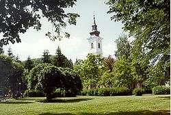
Velika Gorica, on the D30 road route
Petrinja, on the D30 road route
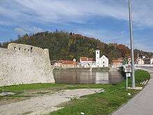
Hrvatska Kostajnica, at the southern terminus of the D30 road
D30 is a state road in central Croatia connecting Velika Gorica, Petrinja and Hrvatska Kostajnica[maps 1] to Croatian motorway network at the A3 motorway Kosnica interchange and to the City of Zagreb via Radnička Road.[1] The road is 79.7 km (49.5 mi) long.[2]
The road, as well as all other state roads in Croatia, is managed and maintained by Hrvatske ceste, state owned company.[3]
Traffic volume
Traffic is regularly counted and reported by Hrvatske ceste, operator of the road.[4] Sections of the road running through Velika Gorica and Petrinja are not covered by the traffic counting sites, but the section is assumed to carry a substantial volume of urban traffic in addition to the regular D30 traffic.
| D30 traffic volume | ||||
| Road | Counting site | AADT | ASDT | Notes |
| |
2014 Velika Mlaka | 37,260 | 35,160 | Between the Ž3109 and D408 junctions. |
| |
2035 Velika Gorica northern bypass | 7,958 | 7,119 | Adjacent to the D408 junction. |
| |
2019 Lekenik | 8,469 | 8,547 | Adjacent to the Ž3230 junction. |
| |
2020 Žažina | 8,439 | 8,600 | Between the D36 and Ž3156 junctions. |
| |
3208 Petrinja - north | 4,718 | 5,306 | Between the Ž3242 and D37 junctions. |
| |
3205 Budičina | 2,034 | 2,583 | Adjacent to the Ž3201 junction. |
| |
3311 Hrvatska Kostajnica | 3,080 | 3,464 | Adjacent to the D224 junction. |
Road junctions and populated areas
| D30 junctions/populated areas | |||||
| Type | Slip roads/Notes | ||||
| |
Kosnica interchange To Zagreb via Radnička Road. Both the D31 to the south of the interchange and Radnička Road to the north are double carriage roads The northern terminus of the road. | ||||
| |
| ||||
| |
To Velika Gorica via Sisačka street. The southern terminus of the suburban double carriage road. | ||||
| |
Vukovina | ||||
| |
Buševec | ||||
| |
Ogulinec | ||||
| |
Peščenica Ž3151 to Brežane Lekeničke and Cerje. Ž3292 to Peščenica railway station. | ||||
| |
Lekenik | ||||
| |
Ž3230 to Poljana Lekenička | ||||
| |
Dužica Ž3157 to Greda. | ||||
| |
The D30 and D36 roads are concurrent to the south of the junction. | ||||
| |
Ž3156 to Žažina | ||||
| |
The D30 and D36 roads are concurrent to the north of the junction. | ||||
| |
Ž3156 to Mala Gorica | ||||
| |
Brest Pokupski Ž3242 to Vurot, Stara Drenčina and Staro Pračno. | ||||
| |
The D30 and D37 roads are concurrent to the east of the junction. | ||||
| |
Petrinja The D30 and D37 roads are concurrent to the west of the junction. Ž3200 to D37 state road. | ||||
| |
Donja Budičina | ||||
| |
Ž3201 to Donja Mlinoga | ||||
| |
Moštanica | ||||
| |
Blinja Ž3208 to Mađari. | ||||
| |
Bijelnik | ||||
| |
Ž3240 to Gornja Mlinoga | ||||
| |
Ž3244 to Mala Gradusa and Drljača. | ||||
| |
Knezovljani | ||||
| |
Umetić | ||||
| |
Ž3241 to Mečenčani and Borojevići. | ||||
| |
Donji Kukuruzari | ||||
| |
Panjani | ||||
| |
Hrvatska Kostajnica | ||||
| |
Hrvatska Kostajnica border crossing to Bosnia and Herzegovina.[5] The road extends to Bosanska Kostajnica, Bosnia and Herzegovina. The southern terminus of the road. | ||||
1.000 mi = 1.609 km; 1.000 km = 0.621 mi
| |||||
Maps
- ↑ Overview map of the D30 (Map). OpenStreetMap. Retrieved July 22, 2014.
Sources
- ↑ "Regulation on motorway markings, chainage, interchange/exit/rest area numbers and names". Narodne novine (in Croatian). May 6, 2003.
- ↑ Ministry of Sea, Transport and Infrastructure (Croatia) (July 18, 2014). "Odluka o razvrstavanju javnih cesta" [Decision on categorization of public roads]. Narodne novine (in Croatian) (094/2014). Archived from the original on 2016-03-04.
- ↑ "Public Roads Act". Narodne novine (in Croatian). December 14, 2004.
- ↑ "Traffic counting on the roadways of Croatia in 2013 - digest" (PDF). Hrvatske ceste. May 2014. Retrieved 2014-07-22.
- ↑ "Map of border crossings and customs office areas" (PDF). Customs Administration of the Republic of Croatia (in Croatian). March 6, 2008.
This article is issued from Wikipedia - version of the 12/4/2016. The text is available under the Creative Commons Attribution/Share Alike but additional terms may apply for the media files.