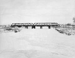
DOE Bridge over Laramie River
|
DOE Bridge over Laramie River | |
|
The bridge in 1982 | |
  | |
| Nearest city | Bosler, Wyoming |
|---|---|
| Coordinates | 41°35′32″N 105°39′23″W / 41.59222°N 105.65639°WCoordinates: 41°35′32″N 105°39′23″W / 41.59222°N 105.65639°W |
| Area | less than one acre |
| Built | 1926 |
| Built by | Swenson, N.A. |
| Architectural style | Pratt half-hip pony truss |
| MPS | Vehicular Truss and Arch Bridges in Wyoming TR |
| NRHP Reference # | 85000411[1] |
| Added to NRHP | February 22, 1985 |
The DOE Bridge over Laramie River is a Pratt half-hip pony truss bridge located near Bosler, Wyoming, which carries Albany County Road CNA-740 across the Laramie River. The bridge was built in 1926 by contractor N.A. Swenson; it was originally part of the Lincoln Highway. In 1932, the bridge was replaced and moved to its current location. It is the only two-span Pratt half-hip truss bridge remaining in Wyoming.[2]
The bridge was added to the National Register of Historic Places on February 22, 1985.[1] It was one of several bridges added to the NRHP for its role in the history of Wyoming bridge construction.[2]
References
- 1 2 National Park Service (2010-07-09). "National Register Information System". National Register of Historic Places. National Park Service.
- 1 2 Fraser, Clayton B. (May 24, 1982). "National Register of Historic Places Inventory - Nomination Form: Vehicular Truss and Arch Bridges in Wyoming" (PDF). National Park Service. Retrieved June 1, 2013.
External links
- Photos from the NRHP nomination
- Laramie River Bridge, County Road 740, Bosler vicinity, Albany, WY at the Historic American Engineering Record (HAER)
This article is issued from Wikipedia - version of the 11/30/2016. The text is available under the Creative Commons Attribution/Share Alike but additional terms may apply for the media files.
