Dedgaun
| Dedgaun | |
|---|---|
| Village development committee | |
  Dedgaun Location in Nepal | |
| Coordinates: 27°51′N 84°05′E / 27.85°N 84.08°ECoordinates: 27°51′N 84°05′E / 27.85°N 84.08°E | |
| Country |
 Nepal Nepal |
| Zone | Lumbini Zone |
| District | Nawalparasi District |
| Population (1991) | |
| • Total | 2,975 |
| Time zone | Nepal Time (UTC+5:45) |
Dedhgaun (or Dedgaun) is a village development committee in Nawalparasi District in the Lumbini Zone of southern Nepal. At the time of the 1991 Nepal census it had a population of 2975 people living in 513 individual households.[1]
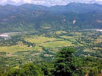
Dedgaun lies on the bank of the Holy Kali Gandaki River and is surrounded by mountains in all sides.
The Dedgaun area, including the new hydro-electricity project at Baundi Khola, was heavily damaged by floods in September 2008.
References
- ↑ "Nepal Census 2001". Nepal's Village Development Committees. Digital Himalaya. Retrieved 18 December 2008.
- Districts at a glance: Nawalparasi by UD Bimala, 2006.
- Introduction of Nepali village: John David Wilson, 2002
- Centre for rural studies, Tribhuvan University

This article is issued from Wikipedia - version of the 12/5/2015. The text is available under the Creative Commons Attribution/Share Alike but additional terms may apply for the media files.