Delaware Route 58
| ||||
|---|---|---|---|---|
| Churchmans Road | ||||
 | ||||
| Route information | ||||
| Maintained by DelDOT | ||||
| Length: | 3.86 mi[1] (6.21 km) | |||
| Existed: | 1985[2] – present | |||
| Major junctions | ||||
| West end: |
| |||
|
| ||||
| East end: |
| |||
| Location | ||||
| Counties: | New Castle | |||
| Highway system | ||||
| ||||

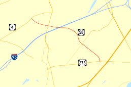
Delaware Route 58 (DE 58), also known as Churchmans Road, is a state highway in New Castle County, Delaware. The route runs from DE 4 adjacent to the Christiana Hospital in Christiana southeast to DE 273 near Hares Corner. The road passes through suburban areas between Wilmington and Newark, intersecting DE 1/DE 7 and Interstate 95 (I-95) in Christiana and DE 37 near the Wilmington Airport. Churchmans Road was originally a county road that was paved in the 1930s and realigned twice in the 1950s. DE 58 was designated onto it in the 1980s.
Route description
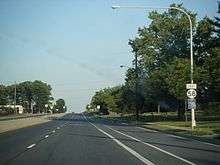
DE 58 begins at an intersection with DE 4 in Christiana, heading east on Churchmans Road, a four-lane divided highway. Past this intersection, the road continues northwest to provide access to Delaware Park Racetrack and the Churchmans Crossing station on SEPTA's Wilmington/Newark Line. From DE 4, the route passes to the north of Christiana Hospital and runs through commercial development to an interchange with DE 1/DE 7. Just east of that interchange, DE 58 forms the southern border of the Stanton Campus of Delaware Technical Community College. The route crosses over I-95, where there is a ramp from I-95 southbound to DE 58 westbound. This is the only direct ramp between DE 58 and I-95, as all other access between the two routes must be made via DE 1/DE 7.[3][4]
Past I-95, DE 58 becomes a two-lane undivided road and heads to the southeast through residential areas, crossing the Christina River. The route curves south through commercial development, widening back into a four-lane divided highway and intersecting DE 37. Past the intersection with DE 37, DE 58 continues southeast as a two-lane undivided road and skirts the southwestern edge of Wilmington Airport. The route passes through light industrial development and continues to its terminus at DE 273 near Hares Corner.[3][4]
DE 58 has an annual average daily traffic count ranging from a high of 26,570 vehicles at the DE 1/DE 7 interchange to a low of 10,257 vehicles at the DE 37 intersection.[1] None of DE 58 is part of the National Highway System.[5]
History
What is now DE 58 existed as a county road by 1920.[6] The entire road was paved by 1936.[7] By 1952, the current alignment of Churchmans Road was constructed around Wilmington Airport, with a portion of the original road being removed.[8] The current alignment of Churchmans Road west of DE 7 was built two years later.[9] DE 58 was designated onto its current alignment in 1985.[2] In 1999, the intersection at DE 1/DE 7 was converted into an interchange.[10]
Major intersections
Mileposts run from east to west. The entire route is in New Castle County.
| Location | mi[1] | km | Destinations | Notes | |
|---|---|---|---|---|---|
| Christiana | 3.86 | 6.21 | Western terminus | ||
| 3.03 | 4.88 | DE 1/DE 7 exit 166, access to Delaware Technical Community College | |||
| 2.53 | 4.07 | Ramp from I-95 south to DE 58 west, I-95 exit 4B | |||
| | 1.14 | 1.83 | |||
| Hares Corner | 0.00 | 0.00 | Eastern terminus | ||
| 1.000 mi = 1.609 km; 1.000 km = 0.621 mi | |||||
See also
 U.S. Roads portal
 Delaware portal
References
- 1 2 3 Staff (2011). "Traffic Count and Mileage Report: Interstate, Delaware, and US Routes" (PDF). Delaware Department of Transportation. Retrieved May 17, 2012.
- 1 2 Delaware Department of Transportation (1985). Official State Highway Map (PDF) (Map). Dover: Delaware Department of Transportation. Retrieved November 24, 2015.
- 1 2 Delaware Department of Transportation (2008). Delaware Official Transportation Map (PDF) (Map). Dover: Delaware Department of Transportation. Retrieved November 24, 2015.
- 1 2 Google (February 6, 2011). "overview of Delaware Route 58" (Map). Google Maps. Google. Retrieved February 6, 2011.
- ↑ National Highway System: Delaware (PDF) (Map). Federal Highway Administration. 2010. Retrieved February 10, 2012.
- ↑ Delaware State Highway Department (1920). Official Road Map (PDF) (Map). Dover: Delaware State Highway Department. Retrieved November 24, 2015.
- ↑ Delaware State Highway Department; The National Survey Co. (1936). Official Road Map of the State of Delaware (PDF) (Map) (1936–37 ed.). Dover: Delaware State Highway Department. Retrieved November 24, 2015.
- ↑ Delaware State Highway Department (1952). Official Highway Map of Delaware (PDF) (Map) (1952–53 ed.). Dover: Delaware State Highway Department. Retrieved November 24, 2015.
- ↑ Delaware State Highway Department (1954). Official Highway Map of Delaware (PDF) (Map) (1954–55 ed.). Dover: Delaware State Highway Department. Retrieved November 24, 2015.
- ↑ "I-95 Corridor Projects". Delaware Department of Transportation. Archived from the original on July 11, 2012. Retrieved October 20, 2014.
External links
 Media related to Delaware Route 58 at Wikimedia Commons