Doel

Doel is a subdivision of the municipality of Beveren in the Flemish province of East-Flanders. It is located near the river the Scheldt, in a polder of the Waasland.
History
The first mention of the village dates from 1267, when "The Doolen" name is first mentioned. Until the 18th century the village was an island surrounded by purposefully flooded land, with the remainder, north of the village, known as "The Drowned Land of Saeftinghe". The "Eylandt den Doel" is completely surrounded by old seawalls. The dike encloses the hamlets of "Sweet Verge", "Saftingen", "Rapenburg" and "Ouden Doel" (Olden Doel).
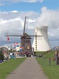
The Doel polder site is unique to Belgium and dates back to the Eighty Years War (1568-1648). The typical checkerboard pattern dates from 1614, when these geometric farmlands were first mapped, and they have seen little change over the years. This fact makes the village a rare example of regional urbanization.[1] The village has many historic buildings, including the oldest stone windmill of the country (1611), and the only windmill on a sea wall. The Baroque Hooghuis (1613) that is associated with the entourage and holdings of the famous 17th century Antwerp painter, Peter Paul Rubens.[2]
Some of the other historical and cultural buildings in the town area are the "Reynard Farm" (De Reinaerthoeve), with a monumental farmhouse and barn. "De Doolen" is a historic school. "De Putten", or "The Wells", is a peat extraction area and has an historically unique 18th-century farmstead and inn site "The Old Hoefyzer", with one of the last remaining historic barns.
Nuclear Plant Doel
Electrabel-owned Nuclear Plant Doel is located to the north of the village of Doel. Its 4 reactors can produce a total output of 2.8 GW of electricity for customers in Belgium, the Netherlands and Germany.
Doel demolition
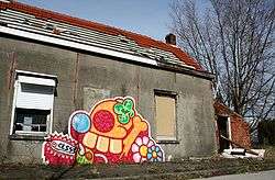
Doel is threatened with complete demolition due to the future enlargement of the Port of Antwerp. This has seen many people having to sell their homes to the development corporation of that enlargement. Many historical buildings will be destroyed.

An author says in one magazine article concerning the demolition of the village, "The Belgian village of Doel was reclaimed from the river Scheldt at the beginning of the 17th century. Three hundred years later and the village that would grow behind the sea wall is under threat. The threat comes not from a failing dyke or an unexpectedly sudden rise in water levels, but rather from the expanding Port of Antwerp and its insatiable need for more and more land along the Scheldt in which to grow. Now, Doel, the last of the Belgian polder villages on the banks of the Scheldt near the North Sea, faces possible demolition. The construction of a large dock and container terminal capable of receiving deep-sea ships is already underway on a site immediately next to the village, and the Port Authority proposes building a second one where the village now stands."[3]
A memorial to British soldiers killed nearby during World War II was removed from the town square during the early morning hours in 2011, according to a BBC report[4]
See also
References
External links
- AVN.be, AVN plants page
- Erfgoedgemeenschap Doel & Polder (in Dutch). See: Heritage and Community of Doel (in English).
- Residents Association Doel 2020.
- Doel: The ghost town graffiti artists tried to save
Coordinates: 51°19′29″N 4°15′31″E / 51.32472°N 4.25861°E