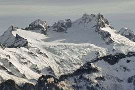
Dome Glacier
| Dome Glacier | |
|---|---|
|
Dome Glacier (center) | |
 Dome Glacier Location in Washington | |
| Type | Alpine glacier |
| Location | Skagit County, Washington, U.S. |
| Coordinates | 48°18′20″N 121°02′20″W / 48.30556°N 121.03889°WCoordinates: 48°18′20″N 121°02′20″W / 48.30556°N 121.03889°W[1] |
| Length | .80 mi (1.29 km) |
| Terminus | Icefall/Barren rock |
| Status | Retreating |
Dome Glacier is in Snoqualmie National Forest in the U.S. state of Washington and is on the north slopes of Dome Peak. Dome Glacier flows generally west for a distance of approximately .80 mi (1.29 km), maintaining a generally shallow gradient between 8,600 to 7,600 ft (2,600 to 2,300 m) at which point it descends in a large icefall to approximately 6,900 ft (2,100 m). An arête separates the glacier from Dana Glacier to the northwest and Chickamin Glacier to the east.[2]
See also
References
- ↑ "Dome Glacier". Geographic Names Information System. United States Geological Survey. Retrieved March 10, 2013.
- ↑ Dome Peak, WA (Map). TopoQwest (United States Geological Survey Maps). Retrieved March 10, 2013.
This article is issued from Wikipedia - version of the 1/30/2016. The text is available under the Creative Commons Attribution/Share Alike but additional terms may apply for the media files.
