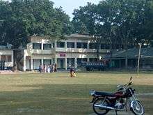
Domrakandi High School
Domrakandi High School (Bengali: ডোমরাকান্দি উচ্চ বিদ্যালয়) is situated in the village of Domrakandi, Faridpur Sadar Upazila, Faridpur District, Bangladesh. It was established in 1969. The school is situated at the same premises as Domrakandi Ideal Government Primary School and the Upazila Resource Centre.
Kobi Jasimuddin Matri Sarak (Poet Jasimuddin's Mother Road) runs along the west of the school campus. Domrakandi Graveyard is to the south of the school.
Students from surrounding villages, who pass their primary education, attend this school for further study.

History
The initiative of establishing the school was mainly taken by the prominent educationist of the district, Abdul Hamid, the then president of the Primary Teachers Association of Faridpur district and headmaster of Domrakandi Ideal Government Primary School. Name of those persons who donated land for the school is given below:
BRAC-Abdul Hamid Public Library
BRAC-Abdul Hamid Public Library is the joint initiative of BRAC and Domrakandi High School. The library was established in 2004 and named after the founder of the school, Abdul Hamid. The library is situated in the ground floor of the main building of the school.
Extracurricular activities
Every year the school celebrates the national festivals on its campus. On 21 February, for International Mother Language Day, a provath feri is arranged. The school has a shahid minar in its own campus so the students and teachers give flowers and pay homage to the martyrs of the Bengali Language Movement of 1952. It celebrates 26 March (Independence Day of Bangladesh) and 16 December (Victory Day of Bangladesh). Bengali New Year, the pohela boishakh, is celebrated.
Students participate in competitions, and games like football, badminton, and handball. The students are involved in Bangladesh Boys Scout, Girls Guide, and Debate.
Alumni association
Domrakandi High School Alumni Association is a Facebook-based group of former students.
References
- District Map for Faridpur Sadar Upazila
- The Daily Star-Robi English Fair - EnvNews
- Board of Intermediate and Secondary Education, Dhaka
Coordinates: 23°34′40″N 89°48′7″E / 23.57778°N 89.80194°E