Donegall Road
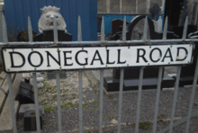 Street sign near Broadway. | |
| Former name(s) |
Blackstaff Lane Blackstaff Road |
|---|---|
| Maintained by | Belfast City Council |
| Location | Shaftesbury and Beechmount, Belfast |
| Postal code | BT12 5 |
| Coordinates | 54°35′19″N 5°57′24″W / 54.5886°N 5.9567°WCoordinates: 54°35′19″N 5°57′24″W / 54.5886°N 5.9567°W |
| West end | Falls Road |
| Major junctions |
Broadway roundabout: North → Southeast → Boucher Road South → Northwest → Broadway |
| East end | Shaftesbury Square |
The Donegall Road is a residential area and road traffic thoroughfare that runs from Shaftesbury Square on the "Golden Mile" to the Falls Road in west Belfast. It is bisected by the Westlink – M1 motorway. The largest section of the road, east of the Broadway junction with the Westlink, is predominantly loyalist. The remainder is predominantly republican.
Overview
The eastern side the road and the streets leading from it, are predominantly Protestant and include the well-known Sandy Row and The Village areas. The Village, an area centred on the loyalist section of Broadway and vaguely conforming to the upper half of the Protestant section of the road, was said to have been given the name by African-American GIs stationed at a base on Maldon Street during the Second World War, who described their occasional trips to the shops in the area as "going to the village".[1] Previously the area was locally known by a number of names including Broadway, Donegall Road, Blackstaff, Linfield and Windsor but the Village name caught on and is still in common usage.[1] The Greater Village Regeneration Trust extends the definition further to cover the entire Protestant part of the road as well as Sandy Row.[2]
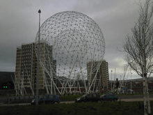
Most of the housing is of the 'two up, two down' (many of them converted) red-bricked terraced variety. The area is mostly working class, but has become a catchment area for student rental accommodation due to its close proximity to Queen's University. Across Broadway in West Belfast the demographics change as the road forms the southern border of the almost exclusively Roman Catholic St. James' area. Located where this section of the road meets the Broadway intersection is the Park Centre, a shopping centre built on the former site of Celtic Park, the home of the now defunct Belfast Celtic.[3] The roundabout at this intersection is also home to Rise, a huge spherical metal sculpture completed in 2011.[4]
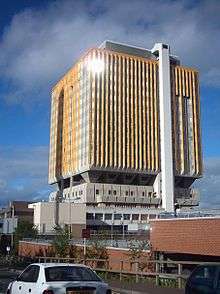
The road provides access to the Belfast City Hospital and the City Hospital railway station. Travelling outwards from the city centre also takes one to the Broadway entrance of the Royal Victoria Hospital. The road gets particularly congested at peak times. It is bordered by the Lisburn Road, the "Golden Mile" and Sandy Row.
A number of churches are to be found both on the road itself and the adjacent streets. Broadway Gospel Hall, St. Simon's Church of Ireland, Donegall Road Methodist Church, Donegall Road Gospel Hall, Richview Presbyterian Church,[5] St. Aidan's Church Hall, Church of the Nazarene on Roseland Place[6] and the William Tyndale Memorial Free Presbyterian Church on Donegall Avenue.
History
The road is named after the Marquess of Donegall, from a prominent family in the Peerage of Ireland which have given their name to a number of locations in Belfast. It was originally known as Blackstaff Lane and subsequently Blackstaff Road before being given its current name.[7] The Blackstaff name refers to the Blackstaff River, a waterway that flows in the area and forms one of a number of minor river networks around Belfast.
The Troubles
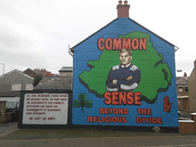
During the Troubles the Donegall Road was the scene of a number of attacks by paramilitaries from both sides. In April 1972 Joseph Gold, a British Army soldier, was killed on the road after stopping a PIRA vehicle at a check point.[9]
On 29 January 1973 Peter Watterson, a 15-year-old Catholic civilian, was shot dead as he stood outside a shop at the corner of the Donegall and Falls Roads whilst two days later the body of another Catholic teenager, Gabriel Savage, was found on a grass verge on the Donegall Road. Both killings are recorded as the work of unspecified loyalists.[10] Henry McDonald and Jim Cusack however say that both killings were the work of a UDA team based in the Village area.[11] The man believed to be the leader of that team was Francis 'Hatchet' Smith who was killed by the IRA in retaliation for the killing of the children, just a few days later in Rodney Drive. Smith's family would also be connected to one of the most brutal murders in the history of the conflict, as his sister Christine Smith was convicted of the murder of Ann Ogilby, who was beaten to death by a team of female UDA members, while her child was sent to the shop to buy sweets. Smith was aged 16 at the time. Ogibly's 'romper room' murder took place in a discused bakery in Sandy Row near the Donegall Road which had been converted to a UDA club; her child heard her screems on return from buying the sweets. On 13 May of the same year, two more soldiers, Thomas Taylor and John Gaskell, were killed by a PIRA explosive left in an abandoned factory on the nationalist part of the road, whilst on 5 July, Catholic Robert Clarke was killed at his place of work by the UDA.[10] On 29 September 1974 Gerard McWilliams, a Catholic, was found stabbed to death in another UDA attack.[12] The following year on 28 April, the UDA attempted to kill another Catholic working on railway lines close to the Donegall Road, but they mistakenly shot and killed his colleague Samuel Grierson, a Protestant.[13]
During the 1980s, Loyalist paramilitaries from the Donegall Road also killed innocent civilian taxi driver Paddy McAllister in Rodney Drive, while IRA volunteer James 'Skipper' Burns was shot and killed in his house in the same street by the UVF. Previously, in 1979, Sadie Larmour, an innocent, middle-aged woman had met the same fate, when she was shot dead in her home. In 1984, Loyalist paramilitary figure Michael Stone would also murder milkman Paddy Brady, who served the area, leaving a nearby dairy. Roy Butler, an off-duty member of the Ulster Defence Regiment was killed by the PIRA, whilst he shopped at Park Centre on 2 August 1988. In late 1991, the road was the scene of four murders in quick succession. On 10 August Catholic civilian James Carson was shot and killed in his shop on the corner of the Donegall and Falls Roads, in an attack claimed by the "Loyalist Retaliation and Defence Group", actually a code name used by the Ulster Volunteer Force (UVF). On 10 September John Hanna, a 19-year-old member of the UVF, was killed by the PIRA at his home in the Village. The republican group struck again on 13 November, when they entered a house on Lecale Street in the Village and killed William Kingsberry and his stepson Samuel Mehaffey. Kingsberry was a member of the Ulster Defence Association and Mehaffey was with the Red Hand Commando (RHC).[14]
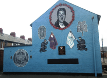
On 7 September 1993 Stephen McKeag, and two other volunteers in C-Company of the UDA West Belfast Brigade, entered a hairdresser's shop on the upper Donegall Road and shot the proprietor Sean Hughes dead. Although brought to trial, McKeag – known as "Top Gun" – was not convicted after eyewitness testimony did not stand up to scrutiny.[15] The following year, the RHC killed 31-year-old Margaret Wright at a social club on Meridi Street, and dumped her body in an empty house in the Village. Wright was taken for a Catholic although in fact she was Protestant.[16] The most recent sectarian murder to occur on the road took place on 21 January 1998 when the UDA shot and killed Catholic Benedict Hughes, outside his place of work on Utility Street near Sandy Row.[17]
In terms of paramilitary organization, the Donegall Road has also seen much activity. In late 1970 John McKeague, who had earlier founded the Shankill Defence Association, attempted to establish a similar "defence association" in the area amongst loyalist residents, but the plan floundered when leaders of the local branch of the Ulster Constitution Defence Committee warned their members and supporters not to associate with McKeague, whilst also spreading the rumour that he was a "fruit".[18] The UDA would soon take root on the Donegall Road however, forming part of the movement's South Belfast Brigade. Variously commanded by John McMichael, Jackie McDonald and Alex Kerr, the South Belfast Brigade covered the largest area of any UDA brigade, including not only south Belfast but all of Lisburn and everywhere in between and, despite its name, active units as far away as South County Down, Cookstown, Lurgan and even County Tyrone and County Fermanagh.[19] The Village area of the Donegall Road was a centre of activity for the UDA, and the unit it shared with the neighbouring Sandy Row was one of the brigade's two most active units, along with that in Lisburn.[20] Alex Kerr would later switch from the UDA to the Loyalist Volunteer Force and his move briefly gained some support in the Village, where graffiti attacking the UDA-linked Ulster Democratic Party appeared. This however proved short-lived, and before long Kerr was forced to flee Belfast for the LVF's Mid-Ulster base of operations.[21]
The UVF have generally played second fiddle to the UDA on the Donegall Road with only Donegall Pass, a thoroughfare connecting the base of the Donegall Road to the Ormeau Road, recognised as a true stronghold.[22] A UVF memorial garden stood on Nubia Street in the area, although in 2008 it was replaced by a children's playground.[23] A series of racially motivated attacks, carried out on the homes of immigrants in the area in January 2004, were blamed on local members of the UVF, with even the local spokesman for the UVF-linked Progressive Unionist Party (PUP) conceding that UVF members had been behind the attacks. He did however add that the UVF leadership had not sanctioned the attacks.[24] Four members who were said to be behind the attacks were subsequently "arrested" by the UVF leadership, who issued claims that two of those held responsible had links to the far right British National Party.[25] The leader of the Donegall Road UVF was subsequently stood down by Supreme Command.[26]
Relations between the UVF and the UDA in the area have not always been cordial, and as late as 2004 a UVF band parade in the Village was cancelled following mediation by the PUP, over fears that the march could lead to clashes between UDA and UVF supporters.[22]
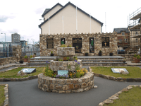
Republican activity in the St. James's area of the Donegall Road is commemorated by a garden of remembrance as pictured. 21-year-old Peter Wilson, one of sixteen people believed or confirmed to have been abducted, killed and buried in unmarked graves by republicans, and known collectively as "the Disappeared", was a native of the St. James's area. Wilson disappeared in July 1973 with his body not recovered until 2 November 2010.[27]
Sport and culture
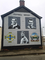
Windsor Park, the home of both Linfield F.C. and the Northern Ireland national football team is accessible from Donegall Avenue, a street that leads off the Donegall Road. As a consequence, both the club and national team are well supported within the road's community and are celebrated by murals in the Village area. The Donegall Road also features in a popular chant that Linfield supporters often sing.[28] A supporters club for Scottish Premier League club Rangers F.C. is located at Barrington Street, adjacent to the Donegall Road.[29] As stated, Belfast Celtic previously made their home on the Donegall Road. However the club left the Irish Football League in 1949, after a series of sectarian incidents at matches, notably at Windsor Park. Their stadium remained as a venue for greyhound racing until it was demolished in the 1980s.[30]
_-_geograph.org.uk_-_1320339.jpg)
Snooker player Alex 'Hurricane' Higgins also grew up on the road, having been born on Abingdon Drive.[31] He was a regular visitor to the local snooker hall, the Jampot Club, before he went on to win the World Snooker Championship for the first time in 1972.[32] Higgins is commemorated by a piece of public art on the road.[33]
Popular singer Ruby Murray was born in Moltke Street, just off the Donegall Road. Like Higgins, Murray's ties to the area have been commemorated artistically, in this case by a photographic montage on the side of the Road's Credit Union.[34]
The Donegall Road Carnegie library opened on 5 March 1909, one of three Carnegie libraries in Belfast.[35] Sold by the council in the early 1990s, it was restored and converted into offices in 1999.[36] It is presently disused.
Politics
For representation on Belfast City Council the Donegall Road is split between the Balmoral District Electoral Area, currently represented by Claire Hanna and Bernie Kelly of Social Democratic and Labour Party (SDLP), Tom Ekin of the Alliance Party of Northern Ireland (APNI), Ruth Patterson of the Democratic Unionist Party (DUP), Máirtín Ó Muilleoir of Sinn Féin and Bob Stoker of the Ulster Unionist Party (UUP),[37] and the Laganbank District Electoral Area, an area currently represented by Kate Mullen and Pat McCarthy of the SDLP, Catherine Curran of the APNI, Deirdre Hargey of Sinn Féin and Christopher Stalford of the DUP.[38] It is part of the Belfast South constituency for the House of Commons, with Alasdair McDonnell of the SDLP serving as MP, as well as the Belfast South constituency of the Northern Ireland Assembly which is represented by Conall McDevitt and Alasdair McDonnell of the SDLP, Anna Lo of the APNI, Michael McGimpsey of the Ulster Unionist Party, Alex Maskey of Sinn Féin and Jimmy Spratt of the DUP.
References
| Wikimedia Commons has media related to Donegall Road. |
- 1 2 Billy Dickson, "American GIs Helped Make Broadway Famous", South Belfast Community Telegraph, 26 January 2012
- ↑ Greater Village Regeneration Trust
- ↑ Park Centre
- ↑ RISE sculpture – Broadway Roundabout
- ↑ Richview Presbyterian Church
- ↑ Church of the Nazarene Lisburn
- ↑ Myths, Legends And Facts On Olde Belfast
- ↑ Urban regeneration: Village in a city
- ↑ Sutton Index of Deaths 1972
- 1 2 Sutton Index of Deaths 1973
- ↑ McDonald & Cusack 2004, pp. 53–55
- ↑ Sutton Index of Deaths 1974
- ↑ Sutton Index of Deaths 1975
- ↑ Sutton Index of Deaths 1991
- ↑ McDonald & Cusack 2004, p. 2
- ↑ Sutton Index of Deaths 1994
- ↑ Sutton Index of Deaths 1998
- ↑ McDonald & Cusack 2004, p. 15
- ↑ McDonald & Cusack 2004, pp. 186–187
- ↑ McDonald & Cusack 2004, p. 187
- ↑ McDonald & Cusack 2004, pp. 278
- 1 2 Parade Scrapped
- ↑ UVF garden now a kids' playground
- ↑ Loyalists behind racist attacks
- ↑ UVF move in to take on racist members
- ↑ UVF leader stood down, say reports
- ↑ Violence – Details of 'the Disappeared'
- ↑ "Walking Down The Donegal Road Football Song". Retrieved 4 September 2012.
- ↑ "Blue Nose Bars". Retrieved 4 September 2012.
- ↑ Flynn, Barry (2009). Political Football: The Life and Death of Belfast Celtic. Nonsuch Publishing. ISBN 978-1845889463.
- ↑ "Alex Higgins' funeral taking place in Belfast". BBC News Online. 2 August 2010. Retrieved 4 September 2012.
- ↑ Baxter, Trevor (26 July 2010). "Obituary: Alex Higgins – Two-times world snooker champion whose style of play and wild ways electrified the sport". www.belfasttelegraph.co.uk. Retrieved 4 September 2012.
- ↑ Walker, Michael (30 July 2010). "Belfast says goodbye to Alex Higgins, a troubled and ungovernable man who came to define this volatile city...". dailymail.co.uk. Associated Newspapers Ltd. Retrieved 4 September 2012.
- ↑ "Greater Village Regeneration Trust: About Us". Archived from the original on 10 October 2009. Retrieved 4 September 2012.
- ↑ "Catalogue of the Photographic Exhibition of Irish Carnegie Libraries" (PDF). An Chomhairle Leabharlanna (Library Council of Ireland). Retrieved 4 September 2012.
- ↑ "Directory of Traditional Building Skills" (PDF) (4th ed.). Ulster Architectural Heritage Society and Environment and Heritage Service. 2004: 4. Retrieved 4 September 2012.
- ↑ District electoral area – Balmoral
- ↑ District electoral area – Laganbank
Bibliography
- McDonald, Henry; Cusack, Jim (2004). UDA – Inside the Heart of Loyalist Terror. Penguin Ireland. ISBN 978-1844880201.
External links
- UTV Northern Ireland Troubles Footage: Clips 8, 9 and 10 – Archive video footage of a suspected carbomb in Donegall Road (UTV, 14 April 1972)
