Dunga Bunga
| Dunga Bunga | |
|---|---|
| Town | |
| ڈُونگہ بُونگہ | |
 | |
 Dunga Bunga | |
| Coordinates: 29°27′N 73°09′E / 29.45°N 73.15°ECoordinates: 29°27′N 73°09′E / 29.45°N 73.15°E | |
| Country |
|
| Elevation | 154 m (505 ft) |
| Population | |
| • Estimate (2006) | 100,000 |
| Time zone | PST (UTC+5) |
| Calling code | 063 |
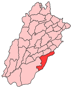
Dunga Bunga (Urdu: ڈُونگہ بُونگہ), is a town in Bahawalnagar District in the Punjab province, Pakistan. It located on the Bahawalnagar-Fort Abbas road 29 km (18 mi) away from Bahawalnagar. 20 km (12 mi) away from Haroonabad. 39 km (24 mi) away from Faqirwali. 58 km (36 mi) away from Khichiwala. 77 km (48 mi) away from Fort Abbas. The city hosts the Union council of Bahawalnagar Tehsil[1] and is located near to the city of Bahawalnagar at 29°45'0N 73°15'0E with an altitude of 154 metres (505 ft).[2] It lies on the Haroonabad-Bahawalnagar road.
The population of Dunga Bunga is around 100,000 according to the 2006 census. Dunga Bunga has more than 50 neighboring villages. The nearest towns are
Soondha(Soondha town is nearest the border ) soondha is mordrn village )}]
, Gulab Ali, Bara Akuka Dinan Bashnoian Wala (Urdu: دینن بشنوئیاں والہ), Rasulpura, Khraj Purah, Sunder Wali.
Etymology
The name Dunga Bunga is Hindustani. Dunga means downside and bunga means a locality. The name is also associated with two Sikh brother named Dunga and Bunga.
History
Prior to partition of subcontinent Dunga Bunga was populated by "Bishnoi" tribe of Hindus. Dunga Bunga is very close to the Indian border. The border area of Dunga Bunga was used for smuggling to India because for many years there was no line of control.
In 2003 unrest broke out in the town when hospital officials refused to conduct an autopsy on a Tonga driver. The family of the driver were believed to have been treated badly and this resulted in mob violence and police retaliation. By the time calm was restored, 19 police officials were reported injured, a labourer and shopkeeper were killed, and five others were seriously injured. These five were taken to a hospital in Bahawalpur, the district capital.[3]
Union councils
Main Dunga Bunga
The main area of this union council includes Union Council Dunga Bunga. near by villages are sundirwali. Dinan Bashnoian Wala.denun maharanawali. khirajpura. rasoolpura and 2R
Dunga Bashnoian
Dunga Bashnoian includes the Mohala Labana wala far behind Dunga Bunga Bypass. It starts at qureshi chowk and ends at the bypass of Dunga Bunga from the Gulab Ali side. Janaza-Gah and Muhalla Qasaaiyan wala also includes in it. Disposal road and GUJJAR HOUSE also in it. ROAD length 10 km
- Rest House Colony is known as Daman Pura is also attach with Dunga Bishnoin. It is 0pp0site from Rest House Dunga Bunga.
Dunga Akuka
Dunga Akuka consists of the Akuka area. It starts at the main city bazaar of Dunga Bunga include Muhallah Masjid Mahajreen where Sohail Ahmad Alvi's home (Pride of Dunga Bunga) and runs to the veterinary Hospital and Haroonabad Road at the city limits.
Educational institutes
- Leaders Academy (Sohail Alvi)
- Allied Public School (Jamshed Campus)
- The Islamic Public School of Education E/M (R) Dunga Bunga (IPS)
- Government Girls High School
- Government Higher Secondary School for Boys
- Fouji Foundation Model School, Dunga Bunga
- Sir Syed Public School (SSPS)
- Paramount Public School
- First Leads School System
- City Public School
- Fauji Foundation Vocational Training School
- Khushi Muhammad Joyia Public School (JPS) Dunga Bunga
- Government Girls High School
- Government Higher Secondary School for Boys
- Fouji Foundation Model School, Dunga Bunga
- Sir Syed Public School (SSPS)
- Paramount Public School
- First Leads School System
- City Public School
- Fauji Foundation Vocational Training School
- The Islamic Public School of Education E/M (R) Dunga Bunga (IPS)
- Khushi Muhammad Joyia Public School (JPS) Dunga Bunga BWN
Medical Facilities
Medical facilities include a number of private medical clinics, with qualified doctors. Health facilities are primarily being provided by a Rural Health Center situated within the city. A Medical Officer; Dr. Muhammad Azeem and Muhammad Jamil Shahzad have recently been appointed at R.H.C. Dunga Bunga to address to the issues of the area. A veterinary hospital is also present on the Highway Road.
Social Organization
Ujala Foundation is the only organization working in the area since 2006. Ujala Foundation is working for SOCIAL CHANGE THROUGH EDUCATION. Al Maqsood Education Academy is also doing valuable services for the poor students of the locality by providing free books and free coaching facility.
Business Places
Ghalla Mandi (Grain Market), Rao Muratab Market, Moon Market, Thana Bazar, Main Bazar, Gosiya Bazar, chand Market Main Bazar,Rao Muratab Chowk Rao Shoukat Karyna Store &Ice Cream Point .Shani Photo Shop Main Bazar
Banks
Muslim Commercial Bank Ltd. (MCB Bank), Habib Bank Ltd., National Bank of Pakistan Ltd., Zari Taraqiyati Bank Ltd
Notable Persons
Rao Sami Ullah LLM, Hannover Germany, UK
- Recent Chairman Rao Salim Akhter.
- Rao Muratab Ali Khan EX MPA (Late)
- Sabir Ali Gujjar Patrolling Police Officer.
- Hafiz Muhammad Abbas Special Magistrate Price control Minchinabad
- Sohail Abbas s/o Hafiz Muhammad Abbas(Student at Sadiq Public School Bahawalpur)
- Haji Sardar Muhammad Ex Chairman(Businessman)
- Main Tariq Nadeem S/o Haji Sardar Muhammad (Businessman)
- Aqeel Abbas SDO irrigation
References
External links
- Map of Dunga Bunga
- Calm restored to Donga Bonga - Daily Times
- Dunga Bunga Political point of views
- Dunga Bunga Weather Updates
- Dunga Bunga Map
- Population
- Government Elections
- Calling Code Detail
- News and situations