Douglas Parish, New Brunswick
| Douglas | |
|---|---|
| Parish | |
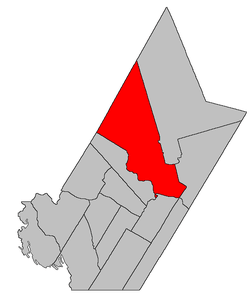 Location within York County, New Brunswick. | |
| Coordinates: 45°58′48″N 66°43′57″W / 45.98°N 66.7325°W | |
| Country |
|
| Province |
|
| County | York |
| Established | 1824 |
| Area[1] | |
| • Land | 1,446.78 km2 (558.60 sq mi) |
| Population (2011)[1] | |
| • Total | 6,081 |
| • Density | 4.2/km2 (11/sq mi) |
| • Pop 2006-2011 |
|
| • Dwellings | 2,370 |
| Time zone | AST (UTC-4) |
| • Summer (DST) | ADT (UTC-3) |
Douglas is a Canadian parish in York County, New Brunswick.[2]
Its population in the 2011 Census was 6,081.
History
Douglas Parish was established in (before 1813) as part of York County and named for (unknown). Douglas Parish included ? Parish until ?, and ? Parish until ?.
Delineation
Douglas Parish is defined in the Territorial Division Act[3] as being bounded:
- South and southeast by the Saint John River and the City of Fredericton; west by a line commencing at the mouth of the Keswick River; thence following the various courses of the said Keswick River up to the mouth of the Howard Brook; thence by the magnet of the year one thousand eight hundred and sixty-nine north forty degrees west till it strikes the County line; northwest by the County line, and east by Stanley and Saint Marys Parishes, including Upper Shores, Lower Shores, Mitchells, Merrithews[lower-alpha 1] and Keswick Islands, and the north range of lots, comprising lots number one to number nine, inclusive, and number thirty-seven to number seventy-one, inclusive, on Sugar Island.
Communities
Parish population total does not include incorporated municipalities (in bold):
|
|
|
Demographics
PopulationPopulation trend[4]
|
LanguageMother tongue language (2006)[5]
|
See also
Footnotes
- ↑ Officially a former name for Lower Shores Island, this may actually refer to one of the small islands between Lower Shores and Upper Shores Islands.
References
- 1 2 2011 Statistics Canada Census Profile: Douglas Parish, New Brunswick
- ↑ New Brunswick Provincial Archives - Douglas Parish
- ↑ "Territorial Division Act (R.S.N.B. 1973, c. T-3)". Government of New Brunswick website. Retrieved 18 August 2016.
- ↑ Statistics Canada: 1996, 2001, 2006 census
- ↑ 2006 Statistics Canada Community Profile: Douglas Parish, New Brunswick

| Subdivisions | |
|---|---|
| Cities | |
| Counties | |
| |
Coordinates: 45°58′48″N 66°43′57″W / 45.98000°N 66.73250°W
This article is issued from Wikipedia - version of the 8/18/2016. The text is available under the Creative Commons Attribution/Share Alike but additional terms may apply for the media files.