Dunakeszi
| Dunakeszi | ||
|---|---|---|
| City | ||
|
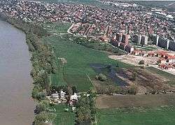
Dunakeszi from above | ||
| ||
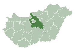
 Dunakeszi Location of Dunakeszi within Hungary | ||
| Coordinates: 47°37′49″N 19°08′28″E / 47.63030°N 19.14123°ECoordinates: 47°37′49″N 19°08′28″E / 47.63030°N 19.14123°E | ||
| Country |
| |
| Region | Central Hungary | |
| County | Pest | |
| Subregion | Dunakeszi | |
| Area[1] | ||
| • Total | 31.06 km2 (11.99 sq mi) | |
| Population (2015 January 1)[1] | ||
| • Total | 41,846 | |
| • Density | 1,347.26/km2 (3,489.4/sq mi) | |
| Time zone | CET (UTC+1) | |
| • Summer (DST) | CEST (UTC+2) | |
| Postal code | 2120 | |
| Area code(s) | 27 | |
| Website | http://www.dunakeszi.hu/ (Hungarian) | |
Dunakeszi [ˈdunakɛsi] is a city in Pest county, Budapest metropolitan area, Hungary. It is located to the north of Budapest on the left bank of the Danube.
Twin towns – Sister cities
Dunakeszi is twinned with:
-
 Cristuru Secuiesc, Romania
 -
 Casalgrande, Italy
 -
 Stary Sącz, Poland
References
- 1 2 "Official statistics" (PDF) (in Hungarian). Hungarian Central Statistical Office. Retrieved 2015-09-22.
External links
- Street map (Hungarian)
- Official website (Hungarian)
| Wikivoyage has a travel guide for Dunakeszi. |
| Wikimedia Commons has media related to Dunakeszi. |
This article is issued from Wikipedia - version of the 8/20/2016. The text is available under the Creative Commons Attribution/Share Alike but additional terms may apply for the media files.


