Duntisbourne Leer
| Duntisbourne Leer | |
 |
|
 Duntisbourne Leer |
|
| OS grid reference | SO975075 |
|---|---|
| – London | 84 mi (135 km) |
| District | Cotswold |
| Shire county | Gloucestershire |
| Region | South West |
| Country | England |
| Sovereign state | United Kingdom |
| Post town | CIRENCESTER |
| Postcode district | GL7 |
| Dialling code | 01285 |
| Police | Gloucestershire |
| Fire | Gloucestershire |
| Ambulance | South Western |
| EU Parliament | South West England |
| UK Parliament | Cotswold |
|
|
Coordinates: 51°45′58″N 2°02′13″W / 51.766°N 2.037°W
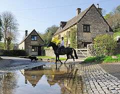
Duntisbourne Leer is in the county of Gloucestershire, and lies within the Cotswolds, a range of hills designated an Area of Outstanding Natural Beauty. It is approximately 10.5 miles (16.9 km) southeast of Gloucester and approximately 4.5 miles (7.2 km) northwest of Cirencester. Nearby villages include Duntisbourne Abbots and Duntisbourne Rouse.
The village was recorded as Duntesborne: Lyre Abbey in the Domesday Book, the name coming from the Old English for "stream of a man called Dunt" and the fact the hamlet belonged to the Abbey of Lyre in Normandy.[1]
References
- ↑ Mills, A. D. (1998). Dictionary of English Place-Names. Oxford University Press. pp. 120. ISBN 0-19-280074-4.
This article is issued from Wikipedia - version of the 3/9/2015. The text is available under the Creative Commons Attribution/Share Alike but additional terms may apply for the media files.