| Area |
Point |
Summit or other feature |
|---|
| Pennsylvania: Eastern Triple Divide |
2,523 feet (769 m)
41°50′48″N 77°50′14″W / 41.84667°N 77.83722°W / 41.84667; -77.83722 |
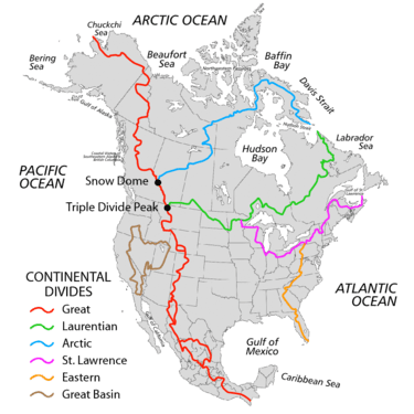
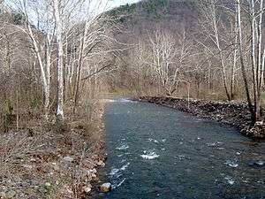
triple watershed point: watersheds of the Atlantic Seaboard, Gulf of Mexico, & Gulf of Saint Lawrence at the respective headwaters of Pine Creek (West Branch Susquehanna River), the Allegheny River, and the Genesee River. |
| Pennsylvania: Babcock Ridge |
|
|
| Pennsylvania: List of tunnels in Pennsylvania |
2,167 feet (661 m)
40°28′53″N 78°33′01″W / 40.48139°N 78.55028°W / 40.48139; -78.55028 |
summit near Allegheny/Gallitzin Tunnels |
| Pennsylvania: Allegheny Mountain |
2,690 feet (820 m)
39°57′41″N 78°51′24″W / 39.96139°N 78.85667°W / 39.96139; -78.85667 |
summit above Allegheny Mountain Tunnel (Pennsylvania Turnpike) |
| Pennsylvania: Allegheny Mountain |
2,460 feet (750 m)
39°48′37″N 78°57′38″W / 39.81028°N 78.96056°W / 39.81028; -78.96056 |
summit above Sand Patch Tunnel |
| Pennsylvania: Savage Mountain |
2,392 feet (729 m)[1]39°45′12″N 78°54′58″W / 39.75333°N 78.91611°W / 39.75333; -78.91611 |
railroad cut on Great Allegheny Passage |
| Pennsylvania/Maryland: Savage Mountain |
2,840 feet (870 m)
39°43′21″N 78°54′51″W / 39.72250°N 78.91417°W / 39.72250; -78.91417 |
highest summit of the Mason–Dixon Line |
| Maryland: Interstate 68 |
2,620 feet (800 m)
39°40′58″N 79°02′16″W / 39.6828°N 79.037704°W / 39.6828; -79.037704 |
crossing near Green Lantern Road |
| Maryland: Savage Mountain |
2,600 feet (790 m)
39°30′27″N 79°13′9″W / 39.50750°N 79.21917°W / 39.50750; -79.21917 |
saddle point at planned route of 1828 C&O Canal |
| Maryland: Backbone Mountain |
3,380 feet (1,030 m)
39°14′15″N 79°29′8″W / 39.23750°N 79.48556°W / 39.23750; -79.48556 |
highest Backbone summit on ECD (near MD/WV border) |
| West Virginia: Eastern Panhandle of West Virginia |
|
Midland Trail: planned crossing for the 19th century James River and Kanawha Turnpike |
|
| West Virginia: US Route 33 North / State Route 55W |
3,295 feet (1,004 m)
38°53′31″N 79°28′04″W / 38.892050°N 79.467781°W / 38.892050; -79.467781 |
Saddle Point at Pendleton County and Randolph County. |
| West Virginia/Virginia: Interstate 64 |
2,460 feet (750 m)
37°47′15″N 80°13′28″W / 37.787539°N 80.224528°W / 37.787539; -80.224528 |
crossing |
| Virginia: Jefferson National Forest |
3,620 feet (1,100 m)
37°20′27″N 80°32′4″W / 37.34083°N 80.53444°W / 37.34083; -80.53444 |
saddle point at Johns Creek headwaters (James River tributary), and near triple point of Mississippi River (W) & Chesapeake Bay (NE)/Albemarle Sound (Roanoke River) (SE) |
| Virginia: Appalachian Trail |
3,397 feet (1,035 m)
37°22′50″N 80°18′23″W / 37.380422°N 80.306368°W / 37.380422; -80.306368 |
Parallel Route Begin |
| Virginia: Appalachian Trail |
3,224 feet (983 m)
37°20′37″N 80°21′53″W / 37.343516°N 80.364647°W / 37.343516; -80.364647 |
Parallel Route Begin |
| Virginia: Interstate 81 |
2,180 feet (660 m)
37°07′43″N 80°22′17″W / 37.128708°N 80.371299°W / 37.128708; -80.371299 |
crossing |
| Virginia: Christiansburg, VA |
2,180 feet (660 m)
37°05′41″N 80°26′44″W / 37.094853°N 80.445558°W / 37.094853; -80.445558 |
2940 Riner Rd, Christiansburg, VA 24073 |
| Virginia: Interstate 77 |
2,860 feet (870 m)
36°39′03″N 80°42′20″W / 36.650896°N 80.705609°W / 36.650896; -80.705609 |
crossing |
| North Carolina: Thurmond Chatham Wildlife Management Area |
36°22′38″N 81°13′15″W / 36.377344°N 81.220722°W / 36.377344; -81.220722 |
triple point of New River and Yadkin/West Prong Roaring rivers |
| North Carolina: Interstate 40 |
2,880 feet (880 m)
35°37′06″N 82°15′47″W / 35.618233°N 82.263007°W / 35.618233; -82.263007 |
crossing |
| North Carolina: Interstate 26 |
2,130 feet (650 m)
35°17′24″N 82°24′07″W / 35.290048°N 82.40193°W / 35.290048; -82.40193 |
crossing |
| North Carolina: U.S. Route 276 |
2,910 feet (890 m)
35°07′47″N 82°38′21″W / 35.129807°N 82.63921°W / 35.129807; -82.63921 |
crossing |
| North Carolina: U.S. Route 178 |
2,694 feet (821 m)
35°05′46″N 82°48′34″W / 35.096133°N 82.80940°W / 35.096133; -82.80940 |
crossing, approx. 1 mile north of NC/SC border |
| North Carolina: NC 226 and Blue Ridge Parkway |
2,820 feet (860 m)
35°51′10″N 82°03′03″W / 35.85266°N 82.0507166°W / 35.85266; -82.0507166 |
|
| North Carolina/South Carolina: French Broad watershed |
|
tributary of the Tennessee River along NC/SC border dividing mountain ridges running southeast meets Santee watershed flowing into Atlantic |
| North Carolina/South Carolina: Sassafras Mountain |
3,564 feet (1,086 m)
35°03′53″N 82°46′38″W / 35.06472°N 82.77722°W / 35.06472; -82.77722 |
located along the South Carolina-North Carolina border in northern Pickens County, South Carolina and southern Transylvania County, North Carolina nearest to the town of Rosman, North Carolina |
| North Carolina/South Carolina: Savannah watershed |
|
across the border of Pickens County, South Carolina & Greenville County, South Carolina up into Transylvania County, North Carolina, Jackson County, North Carolina, and Macon County, North Carolina to dividing mountain ridges to Tennessee River tributaries |
| North Carolina: Highlands, North Carolina |
4,100 feet (1,200 m)
35°3′15″N 83°12′8″W / 35.05417°N 83.20222°W / 35.05417; -83.20222 |
| North Carolina: Cowee Gap |
4,199 feet (1,280 m)
35°05′27″N 83°08′52″W / 35.09083°N 83.14778°W / 35.09083; -83.14778 |
divides Tennessee (Cullasaja) and Savannah (Chatooga) rivers |
| Georgia: Black Rock Mountain State Park |
3,640 feet (1,110 m)
34°54′53″N 83°20′38″W / 34.91472°N 83.34389°W / 34.91472; -83.34389 |
a Blue Ridge summit |
| Georgia: ACF River Basin at Young Lick |
3,809 feet (1,161 m)
34°49′22″N 83°39′09″W / 34.82278°N 83.65250°W / 34.82278; -83.65250 |
triple point at intersection of 3 GA counties: Hiwassee (Towns Co)/Chattahoochee River (Habersham Co) on the west & on the east: Savannah River (Rabun Co) |
| Georgia: Altamaha watershed |
|
triple point along border of Hall & Banks (GA) counties: Chattahoochee River-Banks (west) & Altamaha River-Hall/Savannah River-Banks (east) |
| Georgia: Suwanee watershed |
|
triple point: Chattahoochee River/Suwanee Creek (west) & Altamaha River (east) |
| Georgia: Interstate 85 |
1,280 feet (390 m)
34°04′31″N 83°55′04″W / 34.075235°N 83.917737°W / 34.075235; -83.917737 |
crossing (1 of 5) |
| Georgia: Interstate 85 |
1,120 feet (340 m)
33°59′53″N 84°04′36″W / 33.998098°N 84.07661°W / 33.998098; -84.07661 |
crossing (2 of 5) |
| Georgia: Norcross, Georgia |
|
through Norcross historic district |
| Georgia: Interstate 85 |
1,050 feet (320 m)
33°54′44″N 84°12′29″W / 33.912202°N 84.207973°W / 33.912202; -84.207973 |
crossing (3 of 5) |
| Georgia: Interstate 285 |
1,020 feet (310 m)
33°48′11″N 84°15′00″W / 33.803115°N 84.250031°W / 33.803115; -84.250031 |
crossing (1 of 2) |
| Georgia: Atlanta |
|
near Dekalb Av |
| Georgia: Interstate 75/85 |
1,020 feet (310 m)
33°45′08″N 84°22′46″W / 33.752354°N 84.37942°W / 33.752354; -84.37942 |
crossing (1 of 4 crossings of I-75/4 of 5 crossings of I-85) |
| Georgia: Interstate 20 |
1,050 feet (320 m)
33°44′28″N 84°24′38″W / 33.741221°N 84.410663°W / 33.741221; -84.410663 |
crossing |
| Georgia: Interstate 85 |
1,000 feet (300 m)
33°39′42″N 84°25′39″W / 33.661782°N 84.4274°W / 33.661782; -84.4274 |
crossing (5 of 5) |
| Georgia: Interstate 75 |
976 feet (297 m)
33°39′19.60″N 84°23′42.52″W / 33.6554444°N 84.3951444°W / 33.6554444; -84.3951444 |
crossing (2 of 4) |
| Georgia: Interstate 285 |
960 feet (290 m)
33°37′51.56″N 84°23′34.40″W / 33.6309889°N 84.3928889°W / 33.6309889; -84.3928889 |
crossing (2 of 2) |
| Georgia: Interstate 75 |
927 feet (283 m)
33°34′29.77″N 84°20′7.67″W / 33.5749361°N 84.3354639°W / 33.5749361; -84.3354639 |
crossing (3 of 4) |
| Georgia: Fall line of the United States |
|
near Macon, Georgia, this intersection is a triple physiographic point of the Piedmont (to the north) and the Gulf & Atlantic coastal plains (southwest & southeast). |
| Georgia: Interstate 75 |
410 feet (120 m)
32°10′16.10″N 83°45′9.25″W / 32.1711389°N 83.7525694°W / 32.1711389; -83.7525694 |
crossing (4 of 4) |
| Georgia: Satilla watershed |
|
triple point: Suwannee (west) & Altamaha River/Satilla River (east) |
| Georgia: St. Marys watershed |
|
triple point: Suwannee (west) & Satilla River/St. Marys River (east) |
| Florida: St. Johns watershed |
|
triple point: Suwannee (west) & St. Marys River/St. Johns River (east) |
| Florida: Interstate 10 |
159 feet (48 m)
30°15′14.64″N 82°23′57.84″W / 30.2540667°N 82.3994000°W / 30.2540667; -82.3994000 |
crossing |
| Florida: Florida Trail |
|
Central Florida crossing over the Florida crustal arch |
| Florida: Withlacoochee watershed |
|
triple point: Suwannee/Withlacoochee River (Florida) (west) & St. Johns River (east) |
| Florida: Miami watershed |
|
triple point: Withlacoochee (west) & St. Johns River/Miami River (east) |
| Florida: Kissimmee/Okeechobee watershed |
|
south point of ECD @ Withlacoochee & Miami/Kissimmee triple point (Kissimmee drains to both Gulf & Atlantic via Lake Okeechobee & Okeechobee Waterway) |
|


