El Morro, New Mexico
| El Morro, New Mexico | |
|---|---|
| Nickname(s): El Morroville or El Morro Village, New Mexico | |
| Coordinates: 35°2′40″N 108°19′13″W / 35.04444°N 108.32028°WCoordinates: 35°2′40″N 108°19′13″W / 35.04444°N 108.32028°W | |
| Country | United States |
| State | New Mexico |
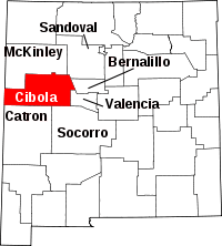
| County | Cibola |
| Government | |
| Elevation[1] | 7,296 ft (2,224 m) |
| Time zone | Mountain (MST) |
El Morro, New Mexico is an unincorporated community in Cibola County, New Mexico, United States, in the northwestern part of the state. It is remotely located along the scenic Highway 53 (also known as the Ancient Way), 38 miles (61 km) from Grants, NM to the northeast and 55 miles (89 km) from Gallup, NM to the northwest. El Morro, New Mexico is named after a nearby sandstone promontory with a pool of water at its base, a desert oasis which the Spanish conquistadors called El Morro (The Headland). The Zuni Indians call it A'ts'ina (Place of Writings on the Rock). Anglo-Americans called it "Inscription Rock". El Morro National Monument is located 1.5 miles (2.4 km) west on Highway 53, along the old Zuni-Acoma Trail, an ancient Pueblo trade route also known as the Ancient Way.
El Morro is an artist community and home of the El Morro Area Arts Council, an art gallery, a trading post / coffee shop, cafe, RV park & campgrounds, feed & seed store, consignment store and healing arts center. El Morro is the social hub for a colorful array of artists, homesteaders and individualists who reside in a 1000+ square mile area, from El Malpais National Monument to the East, Ramah, NM to the West, Zuni Mountains to the North, and Candy Kitchen, NM to the South.
References
External links
- Old School Gallery
- Along The Ancient Way - El Morro Valley Community Website
- Timberlake - Ramah News
- El Morro National Monument - Official National Park Service Website
