Elizabeth Quay
.jpg)
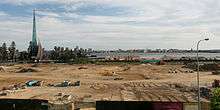
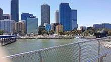
Elizabeth Quay is a mixed-use development project in the Perth central business district. Located on the north shore of Perth Water and centred on the landmark Swan Bells, it is named in honour of Queen Elizabeth II.[1][2][3]
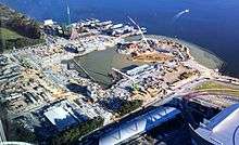
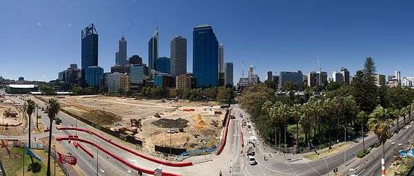
The project includes construction of an artificial inlet on what was previously the Esplanade Reserve, and modifications to the surrounding environs including Barrack Square. The project plan shows nine building sites.[4] Completed facilities are projected to include 1,700 residential apartments, 150,000 square metres of office space and 39,000 square metres of retail space.
Planning Minister John Day and Premier Colin Barnett turned the first sod at the Esplanade Reserve on 26 April 2012,[5][6] and Barnett announced the name "Elizabeth Quay" on 28 May 2012.[1] Construction of the inlet and associated infrastructure were completed in January 2016, ahead of the Perth International Arts Festival and Fringe World.[7] The quay was officially opened on 29 January 2016.[8] Construction of the associated buildings has been estimated to be completed by 2018, with the Metropolitan Redevelopment Authority's marketing and sales being undertaken between 2014 and 2022.
Announcements and construction issues


In February 2011, Premier Colin Barnett and Perth Lord Mayor Lisa Scaffidi confirmed plans for the project and funding which included $270 million from the 2011/12 state budget.[9] The total government outlay would be $440 million with $134 million recovered from property sales to developers.

The project created significant changes to adjacent features such as Riverside Drive,[10] Barrack Square and environs.[11] Other nearby sites such as Supreme Court Gardens and Langley Park were affected through changes in use or additional use. Nearby heritage listed Lawson Apartments and the Weld Club were affected due to pile driving and obstruction of views.
The JJ Talbot Hobbs memorial, a feature of Anzac Day ceremonies for over sixty years, was relocated to the entrance of the Supreme Court Gardens. The Esplanade Kiosk, built in 1927 in the Federation Arts and Crafts style, was dismantled and rebuilt, brick by brick, as a kiosk on the island feature in the new inlet.[12]
While some of the trees in the reserve and surrounding areas were retained, the Moreton Bay Figs along Barrack Street were removed and replaced with London plane trees.
The State Government identified project returns in the order of $1.7 million on the sale of real estate sites to commercial developers, with the whole development projected as a $2.6 billion investment opportunity.[13] There was debate on the speculative nature of the estimates.[14][15]
The Metropolitan Redevelopment Authority[16] launched a publicity campaign for the development, with the slogan "The river. The city. Together again."[17][18] and also had a range of panels on screens surrounding the development site repeating anecdotes about the former esplanade area, as well as text of the material found on the website, and other public relations material.
On 21 April 2012, the MRA released new design guidelines for the development and called for submissions on a second amendment to the Metropolitan Region Scheme.[19] The Minister for Planning granted approval for public comment on the redevelopment scheme and amendments, and the Metropolitan Redevelopment Board approved the Draft Perth Waterfront Design Guidelines.[20][21] MRA chairman Eric Lumsden made comment on the MRA role in the process.[22]
Opposition campaigns
Following the announcement, the proposals created extensive public debate and opposition due to its supposed failure to sustain respect for heritage, and potential risks to the ecology of the river.[23][24][25][26][27][28]
At a "Foreshore Forum" in 2011, organised by the History Council of Western Australia,[29] speakers examined the history and heritage of the site, and expressed concerns about the way in which the heritage aspects of the site were to be interpreted. Speakers suggested that a thorough archaeological examination of the site for European artefacts associated with the early commercial maritime activities and later recreational bathing activities on the site should be included as part of any digging for the proposed inlet.[30] Subsequent discoveries during the excavation process have included a set of timber poles and timber "steps", consistent with pier construction of the 19th century and the formwork for the Barrack Square retaining wall [31][32][33]

Concerns were raised about the impact on the Perth road network resulting from the diversion of Riverside Drive traffic around the new inlet.[34][35][36]
As part of the proposed works the Graham Farmer Freeway had additional lanes installed in the Northbridge Tunnel to encourage motorists to bypass the city. The Royal Automobile Club raised early concerns that loss of the emergency lanes might affect emergency response times.[37] Although a tunnel, either under the inlet, or as part of one of the suggested alternative schemes, has previously been dismissed, the suggestion that a tunnel might be built at some time in the future has not been totally dismissed.[38]
A lobby group named "City Gatekeepers" headed by urban planner Linley Lutton was formed to oppose the plans. The group described the plans as being "badly flawed" and forced through without opportunity for public consultation or comment.[39] Between 500 and 2000 people (depending on the source of the crowd estimate)[40] attended a protest rally organised by the group on the Esplanade on 26 February 2012.[41] Kate Doust, MLC, presented two petitions against the development, one with 8667 signatures and a second with 662 signatures, to the Western Australian Legislative Council on 6 March 2012.[42] A third petition, containing 1,117 signatures, was tabled on 29 March 2012. The City Gatekeepers also released a number of alternative concept designs, one of which included a landbridge over Riverside Drive, and all featuring the retention of all or most of the Esplanade, based upon the heritage values of the site.[43]
Similar comments have been made by other planning and design professionals and by the Western Australian Policy Forum.[15][44]
CityVision also released a number of alternative plans.[45]
Supporters of the project noted that the parcel of land was reclaimed from the Swan River in the 1930s,[46] leading to questions of its heritage value as a decades-old predominantly grassed area and road.
Support for the project included Government Architect Steve Woodlands[47][48] and Sean Morrison of FuturePerth.[49]
Contractors

ARM Architecture were the architects on the development. Urban planner Richard Weller was a lead consultant.[50] Weller also had made comment in his book Boomtown 2050 about the development as an experiment on bringing in new high rise development in the CBD.[51]
The Perth firm Hocking Heritage Studio has identified its involvement with the project.[52]
Leighton Contractors and its parent CIMIC Group, were awarded the principal construction contract in December 2012.[53] Construction included a new inlet, associated roads, parks, promenades, and an island with connecting bridge within a 10 hectare parcel of land. The contract value was $210 million as at 31 December 2012.
Transport
The Esplanade Busport and Esplanade railway station were renamed as the Elizabeth Quay Bus Station and Elizabeth Quay railway station shortly after the Quay's opening in January 2016.[54]
Transperth runs ferries from Elizabeth Quay Jetty to Mends Street Jetty in South Perth.[55]
An electric ferry service operates from Elizabeth Quay ferry terminal to Claisebrook Cove and return.[56]
A cable car to Kings Park has been allowed for in the plans, although this is not included in the initial phase.[57]
Public art
Several pieces of public art adorn Elizabeth Quay:
- Spanda, a 29-metre-tall (95 ft) abstract sculpture[58]
- First Contact,[59] a 5-metre-tall (16 ft) depiction of a bird in a boat[60]
- A statue of Bessie Rischbieth[61]
- Spanda (viewed from north side of Elizabeth Quay)
- First Contact
- Statue of Bessie Rischbieth
See also
References
- 1 2 Redeveloped waterfront name unveiled – ABCNews. Published 28 May 2012. Retrieved 22 February 2013.
- ↑ Cardy, Todd (2012). Perth Waterfront precint (sic) will be called Elizabeth Quay – PerthNow. Published 28 May 2012. Retrieved 22 February 2013.
- ↑ About Elizabeth Quay – Metropolitan Redevelopment Authority. Retrieved 29 May 2012.
- ↑ "Map of Elizabeth Quay". Metropolitan Redevelopment Authority. Retrieved 1 January 2015.
- ↑ Trenwith, Courtney (2012). Work begins on $440 million Perth Waterfront project – The Sydney Morning Herald. Published 26 April 2012. Retrieved 22 February 2013.
- ↑ Perth waterfront works commence – ABCNews. Published 26 April 2012. Retrieved 22 February 2013.
- ↑ "A Bridge Closer to Elizabeth Quay Opening". Retrieved 21 December 2015.
- ↑ "Elizabeth Quay, Perth CBD's new $440m showpiece, finally opened to public". Australian Broadcasting Corporation. 29 January 2016. Retrieved 29 January 2016.
- ↑ "Latest Perth waterfront redevelopment gets a cash boost". WAToday. 15 February 2011.
- ↑ Extra freeway lane to ease congestion – ABCNews. Published 4 March 2012. Retrieved 22 February 2013.
- ↑ "Barrack Square transformation gets green light". Metropolitan Development Authority. 24 January 2012. Retrieved 15 April 2012.
- ↑ Florence Hummerston finds new home at Elizabeth Quay – Metropolitan Redevelopment Authority. Published 11 November 2012. Retrieved 22 February 2013.
- ↑ Perth Waterfront Project Overview Information Sheet – Metropolitan Redevelopment Authority. Retrieved 22 February 2013.
- ↑ Thomson, Chris (2012). Waterfront secrecy slammed – One Perth. Published 5 February 2012. Retrieved 22 February 2013.
- 1 2 An Ugly, Stupid Idea—the Perth Waterfront – WA Policy Forum. Retrieved 22 February 2013.
- ↑ "Act and Scheme". Metropolitan Redevelopment Authority. 24 January 2012. Retrieved 15 April 2012.
- ↑ "About Perth Waterfront". Metropolitan Redevelopment Authority. 5 April 2012. Retrieved 15 April 2012.
- ↑ "Perth Waterfront [advertisement]". The Weekend West. 14–15 April 2012. p. 58.
- ↑ Perth Waterfront design guide revealed – Metropolitan Redevelopment Authority. Published 21 April 2012. Retrieved 22 February 2013.
- ↑ "Public Comment". Metropolitan Redevelopment Authority. Retrieved 25 April 2012.
- ↑ The West Australian, 25 April 2012, page 44, Classified advertisements – Notification of proposed Amendment No.2 to Redevelopment Scheme 2 and Draft Perth Waterfront Design Guidelines
- ↑ The West Australian, 25 April 2012, page 21 Perth's transformation depends on careful planning
- ↑ Thomson, Chris (2010). Heritage showdown dogs Langley Park – OnePerth. Published 5 November 2010. Retrieved 22 February 2013.
- ↑ Bannister, Brooke (2012). Perth's waterfront development debate – 720 ABC Perth. Published 21 February 2012. Retrieved 22 February 2013.
- ↑ Thomas, Beatrice (2012). Splash pool in waterfront vision – The West Australian. Published 23 February 2012. Retrieved 22 February 2013.
- ↑ Thomas, Beatrice (2013). Waterfront quarrel over land value – The West Australian. Published 2 February 2012. Retrieved 22 February 2013.
- ↑ Mullany, Ashlee (2012). Architects challenge foreshore plan – PerthNow. Published 18 February 2012. Retrieved 22 February 2013.
- ↑ Extract from Hansard [ASSEMBLY — Tuesday, 28 February 2012] p357c-359a Mr Michael Sutherland; Mr John Day; Mrs Michelle Roberts; Speaker
- ↑ "More than grass: exploring the Esplanade". History Council of Western Australia. Retrieved 2 January 2015.
- ↑ Gaye Nayton (6 January 2012). "Foreshore treasure: The potential archaeology of the buried Port of Perth" (PDF). Retrieved 2 January 2015.
- ↑ Anthony Deceglie, Peter Law (8 March 2014). "Historic find: Work stopped on Elizabeth Quay after wooden beams dug up". Perth Now. Retrieved 2 January 2015.
- ↑ Alyesha Anderson (25 September 2014). "Discovery of potentially historic stairs stops work on part of Elizabeth Quay waterfront project". Perth Now. Retrieved 2 January 2015.
- ↑ "HARBOUR AND RIVER IMPROVEMENTS.". The West Australian. Perth: National Library of Australia. 18 August 1905. p. 2. Retrieved 2 January 2015.
- ↑ Submission: MRS Waterfront Amendment – CityVision. Published 19 October 2011. Retrieved 24 March 2012.
- ↑ Traffic Chaos – thecitygatekeepers. Retrieved 24 March 2012
- ↑ Closure of Riverside Drive Concerns City – City of South Perth. Published 6 December 2011. Retrieved 24 March 2012
- ↑ Harvey, Ben and Alex Massey (2011). Waterfront traffic woes surface – The West Australian. Published 17 February 2011. Retrieved 24 March 2012
- ↑ Parker, Gareth and Beatrice Thomas (2011). Lib MP urges tunnel under river inlet – The West Australian. Published 10 November 2011. Retrieved 24 March 2012
- ↑ "Our Objectives". thecitygatekeepers.com.au. Retrieved 1 January 2015.
- ↑ "Hundreds in riverside rally". The West. 26 February 2012.
- ↑ "Foreshore protest attracts thousands to Perth Esplanade". WAToday. 26 February 2012.
- ↑ Petition against waterfront presented to Parliament – WA Business News (subscription-only content). Published 6 March 2012. Retrieved 22 March 2013.
- ↑ "City Gatekeepers home page". citygatekeepers.com.au. Retrieved 7 March 2012.
- ↑ Perth's Foreshore Furore – IndesignLive. Published 20 January 2013. Retrieved 23 March 2012.
- ↑ Perth Waterfront Proposals – CityVision. Published 7 January 2011. Retrieved 22 February 2013.
- ↑ "RIVER RECLAMATION.". The West Australian (Perth: National Library of Australia). 25 May 1934. p. 23. Retrieved 5 March 2012
- ↑ "The designs and ideas behind Perth's new waterfront". 720 ABC Perth. 16 February 2011. Retrieved 11 May 2012.
- ↑ "Perth's waterfront development debate". 720 ABC Perth. 21 February 2012. Retrieved 11 May 2012.
- ↑ Sean Morrison (4 July 2008), Perth deserves grand designs — and choice (PDF), retrieved 11 May 2012
- ↑ "Leading landscape architect Richard Weller to head Urban Design Centre". The University of Western Australia. 22 December 2010. Retrieved 11 May 2012.
- ↑ Section pages 355–359 for Perth's New Waterfront with a sub-heading A 'Sky City' test case, and images from 'Ashton Raggatt McDougall' on pages 354,355,358-359 which collectively represent an earlier design scenario. See also 'Vertical Scenarios' 313-353 to understand the general argument for vertical developments, and also pp. 138–139 for newspaper clipping extracts regarding resistance to high rise development in Perth circa 2007–2008 Weller, Richard; Weller, Richard (2009), Boomtown 2050 : scenarios for a rapidly growing city (1st ed.), UWA Publishing, ISBN 978-1-921401-21-3
- ↑ "Perth Waterfront: Department of Planning". Hocking Heritage Studio. Retrieved 15 April 2012.
- ↑ "Elizabeth Quay". CPB Contractors. Retrieved 14 October 2016.
- ↑ Smart names for Elizabeth Quay stations Minister for Transport 12 November 2015
- ↑ Hayley Roman (1 February 2016). "Elizabeth Quay ferry services welcome first rush-hour commuters". Australian Broadcasting Corporation. Retrieved 1 February 2016.
- ↑ "Daily Service". Little Ferry Co. Retrieved 14 October 2016.
- ↑ "The designs and ideas behind Perth's new waterfront". Australian Broadcasting Corporation. 16 February 2011. Retrieved 24 January 2015.
- ↑ "Spanda". Metropolitan Redevelopment Authority. Retrieved 2 February 2016.
- ↑ "First Contact". Metropolitan Redevelopment Authority. Retrieved 2 February 2016.
- ↑ Stephen Bevis (16 December 1015). "Giant bird comes home to roost at quay". The West Australian. Retrieved 2 February 2016.
- ↑ "Bessie Rischbieth Statue". Metropolitan Redevelopment Authority. Retrieved 2 February 2016.
Further reading
- Bolleter, Julian (2015). Take me to the River: The story of Perth's foreshore. Crawley, WA: UWA Publishing. ISBN 9781742586489.
External links
| Wikimedia Commons has media related to Elizabeth Quay. |
- Elizabeth Quay at the Metropolitan Redevelopment Authority website
Coordinates: 31°57′27″S 115°51′25″E / 31.9575°S 115.857°E